Category:Aspres (Pyrénées-Orientales)
Jump to navigation
Jump to search
English: Albères Mountain Range (département of Pyrénées-Orientales, Languedoc-Roussillon région, France)
{{fr|Massif des Albères (Pyrénées-Orientales, Languedoc-Roussillon, France)}
Subcategories
This category has the following 3 subcategories, out of 3 total.
Media in category "Aspres (Pyrénées-Orientales)"
The following 67 files are in this category, out of 67 total.
-
 A hauteur de la face Est de la campane centrale de Fourques.jpg 3,840 × 2,880; 2.52 MB
-
 A hauteur de la face ouest des Campanes de Fourques.jpg 2,880 × 3,840; 2.49 MB
-
 A l'entrée Est de Terrats, tout pointe vers le ciel, à l'image du Massif du Canigou.jpg 3,840 × 2,880; 2.54 MB
-

-
-
 A l'ouest du village de Fourques, se dressent les Campanes.jpg 3,840 × 2,880; 2.49 MB
-
 Aspres 01.jpg 640 × 480; 260 KB
-
 Aspres 02.JPG 640 × 479; 57 KB
-
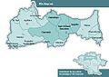
 Aspres sur carte P-O relief.jpg 1,953 × 1,090; 447 KB
-
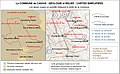
 Aspres-Pyrénées-géologie.jpg 2,468 × 1,212; 503 KB
-
 Aspres-relief-map--OpenCycleMap.jpg 2,454 × 1,845; 2.2 MB
-
 Boule d'Amont.jpg 3,264 × 2,448; 2.9 MB
-
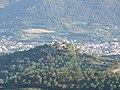
 Caixas mairie depuis Mt-Helena.jpg 4,000 × 3,000; 3.16 MB
-
 Carte topographique des Aspres 2.jpg 3,000 × 1,907; 2.69 MB
-
 Carte topographique des Aspres.jpg 2,518 × 1,601; 2.02 MB
-
 Casefabre village.jpg 3,264 × 2,448; 2.01 MB
-

-
 Chêne-liège et vignes, un destin commun pour la qualité de leur prestigieuse production.jpg 3,840 × 2,880; 2.53 MB
-
 Clocher mur de l'église de TERRATS.jpg 3,840 × 2,880; 2.56 MB
-
 Coll de les Arques - Tour Santa Anna.jpg 4,608 × 3,456; 8.82 MB
-
 Céret au pied des Aspres vu depuis la montée du mas Boher.jpg 3,840 × 2,880; 2.47 MB
-

-
 Depuis le versant Sud du Puig Rabiol, vue du vallon de la Galserana et des Albères.jpg 3,840 × 2,880; 2.49 MB
-

-
 Etage d'une ancienne maison vigneronne de Terrats.jpg 3,840 × 2,880; 2.47 MB
-
 Geology and relief of Caixas.jpg 2,339 × 1,438; 2.48 MB
-
 Geology and relief of Castelnou.jpg 2,422 × 1,698; 2.5 MB
-
-
 Le Canigo' enneigé décore encore Ste-Colombe de la Commanderie durant l'hiver 2021-2022.jpg 3,840 × 2,880; 2.55 MB
-

-
 Le clocher mur de l'église de TERRATS rivalise d'allure avec le Canigou en arrière plan.jpg 3,840 × 2,880; 2.56 MB
-

-
 Le Massif du Canigo' depuis le belvédère de Fourques, au dessus des Campanes.jpg 3,840 × 2,880; 2.56 MB
-

-
 Le Sarrat de les Planas ouvre l'entrée de Montauriol.jpg 3,840 × 2,880; 2.51 MB
-

-
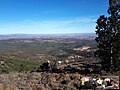
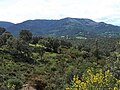
 Les Aspres et le massif des Albères.jpg 4,608 × 3,456; 8.25 MB
-
 Les Campanes de Fourques.jpg 3,840 × 2,880; 2.58 MB
-
 Massif-du-Canigou depuis Les-Aspres (Mont-Helena).jpg 3,765 × 2,824; 2.41 MB
-
 Mont Helena Caixas les Aspres.jpg 1,825 × 1,368; 801 KB
-
 Mont Helena depuis Belpuig.jpg 3,264 × 2,448; 2.67 MB
-
 Montauriol depuis el Caraig.jpg 3,137 × 2,851; 3.25 MB
-
 Municipis dins dels Aspres.jpg 643 × 454; 34 KB
-
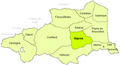 Pays PO Aspres.PNG 558 × 304; 22 KB
-
 Plaine du Roussillon et Albères depuis l'ermitage de Saint-Ferréol.jpg 4,972 × 871; 1.09 MB
-
 Prunet-et-Belpuig carte topographique.jpg 1,466 × 1,985; 812 KB
-
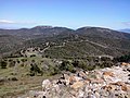
 Roc de Majorca from Mont Helena.jpg 2,720 × 1,506; 2.85 MB
-
 Santa Anna and Canigou massif.jpg 4,608 × 3,456; 8.05 MB
-
 Santa-Anna tables-orientation.jpg 4,608 × 3,456; 11.51 MB
-
 Schiste noir Coll Xatard.jpg 1,788 × 1,163; 643 KB
-
 Serrabona priory from path to Roca Roja.jpg 3,053 × 2,309; 1.95 MB
-
 Sommet du Puig Rabiol par soirée d'automne.jpg 3,840 × 2,880; 2.53 MB
-
 Ste-Colombe-de-la-Commanderie--Canigou.jpg 2,872 × 1,615; 1.09 MB
-
-

-
 Unité des Aspres 2.jpg 2,319 × 2,216; 577 KB
-
 Unité des Aspres.jpg 1,917 × 1,834; 707 KB
-
 Versant sud du Puig Rabiol donnant sur les Albères à l'horizon Sud-Est.jpg 3,840 × 2,880; 2.51 MB
-

-
 Vue de la campagne de Montauriol, au nord-Est de la commune, depuis le Puig Rabiol.jpg 3,840 × 2,880; 2.54 MB
-
-
 Vue du versant Est du Massif du Canigou et des Aspres depuis la pénéplaine de Terrats.jpg 3,840 × 2,880; 2.55 MB
-

-

-

-

-
 Vue vers Notre-Dame-de-Roure.jpg 3,105 × 1,799; 1.1 MB


_%C3%A0_la_Bigne_de_la_Guardia,_%C3%A0_l%27extr%C3%AAme_nord_du_territoire_de_C%C3%A9ret.jpg)


.jpg)


