Category:Armitage Bridge
Jump to navigation
Jump to search
village in West Yorkshire, UK .jpg) | |||||
| Upload media | |||||
| Instance of | |||||
|---|---|---|---|---|---|
| Location | Kirklees, West Yorkshire, Yorkshire and the Humber, England | ||||
 | |||||
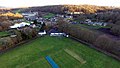
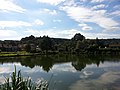
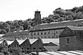
English: Armitage Bridge is a village approximately 3 miles south of Huddersfield, West Yorkshire, England. It is situated between Berry Brow and South Crosland and lies across and on the eastern bank of the Holme valley. The village is dominated by the large former woollen mill of John Brook and Son, reputedly the oldest family business in the country, having been founded in 1541. The mill has now been now converted into the Yorkshire Technology and Office Park. The local "watering hole" in the village is The Monkey Club http://www.freewebs.com/the-monkey-club/index.htm There is also a cricket club which also has a club house / bar.
Media in category "Armitage Bridge"
The following 43 files are in this category, out of 43 total.
-
 Allotments - off Dean Brook Road - geograph.org.uk - 2153683.jpg 640 × 480; 84 KB
-

-
 Armitage Bridge - geograph.org.uk - 3766820.jpg 1,600 × 1,200; 709 KB
-

-

-
 Armitage Bridge viewed from Beaumont Park.jpg 720 × 479; 66 KB
-
 Armitage Bridge village square - geograph.org.uk - 5146614.jpg 1,024 × 768; 139 KB
-
 Armitage Bridge, Huddersfield, West Yorkshire.jpg 960 × 540; 128 KB
-
 Armitage Bridge.jpg 3,264 × 2,448; 2.04 MB
-
 Armitage Road - Meltham Road - geograph.org.uk - 2141406.jpg 640 × 480; 65 KB
-
 Armitage Road, Armitage Bridge - geograph.org.uk - 5148397.jpg 1,600 × 1,065; 653 KB
-

-
 Armitage Road, Netherton - geograph.org.uk - 6982173.jpg 2,000 × 1,515; 1,016 KB
-

-
 Back Armitage Road - Armitage Road - geograph.org.uk - 2153702.jpg 640 × 480; 89 KB
-
 Back Armitage Road, Armitage Bridge - geograph.org.uk - 5148408.jpg 1,600 × 987; 517 KB
-
 Back to the back, back way to Back Armitage Road - geograph.org.uk - 4164097.jpg 683 × 1,024; 170 KB
-
 Bank Foot Lane - Armitage Road - geograph.org.uk - 2153831.jpg 480 × 640; 85 KB
-
 Bankfield Terrace - Armitage Road - geograph.org.uk - 2153650.jpg 640 × 480; 51 KB
-
 Bridge at Armitage Bridge.jpg 1,600 × 1,200; 369 KB
-
 Brooke's Mill, Armitage Bridge.jpg 3,888 × 2,592; 3.59 MB
-
 Club Houses - Armitage Road - geograph.org.uk - 2153710.jpg 640 × 480; 83 KB
-
 Club Houses - Back Armitage Road - geograph.org.uk - 2153695.jpg 640 × 480; 71 KB
-
 Dean Brook Road - off Armitage Road - geograph.org.uk - 2153671.jpg 640 × 480; 86 KB
-
 Dean Brook Road, Armitage Bridge - geograph.org.uk - 5148480.jpg 1,600 × 1,065; 534 KB
-
 Dean Brook Road, Armitage Bridge.jpg 640 × 427; 66 KB
-

-
 Footbridge over the River Holme, Amitage Bridge - geograph.org.uk - 5148394.jpg 1,600 × 1,065; 836 KB
-
 Green door, blue door (8192953183).jpg 1,654 × 3,073; 4.58 MB
-
 Holme valley trees, Armitage Bridge - geograph.org.uk - 1983380.jpg 1,024 × 768; 167 KB
-
 Lane out of Armitage Bridge - geograph.org.uk - 2349967.jpg 1,600 × 1,200; 542 KB
-

-
 River Holme - Armitage Bridge - geograph.org.uk - 2153843.jpg 640 × 480; 124 KB
-
 River Holme - Armitage Bridge - geograph.org.uk - 2153848.jpg 640 × 480; 138 KB
-
 River Holme - Armitage Road - geograph.org.uk - 2153723.jpg 640 × 480; 141 KB
-
 River Holme, Amitage Bridge - geograph.org.uk - 5148377.jpg 1,600 × 1,065; 934 KB
-
 River Holme, Amitage Bridge - geograph.org.uk - 5148387.jpg 1,600 × 1,065; 601 KB
-
 River Holme, Amitage Bridge - geograph.org.uk - 5980014.jpg 640 × 480; 131 KB
-
 Road sign in the River Holme - geograph.org.uk - 5148367.jpg 1,600 × 1,065; 986 KB
-
 Stockwell Vale - Armitage Road - geograph.org.uk - 2153839.jpg 640 × 480; 63 KB
-
 Sundial (8206767470).jpg 2,594 × 2,295; 4.39 MB
-
 The Dyehouse, Armitage Bridge - geograph.org.uk - 4164114.jpg 640 × 427; 72 KB
-


.jpg)


.jpg)

