Category:Abercastle
Jump to navigation
Jump to search
village in the Welsh language speaking area of Pembrokeshire, south-west Wales | |||||
| Upload media | |||||
| Instance of | |||||
|---|---|---|---|---|---|
| Location | Pembrokeshire, Wales | ||||
 | |||||
Català: Abercastell (en anglès, Abercastle) és un poble del comtat de Sir Benfro, en el sud-oest de Gal·les.
Cymraeg: Pentref bychan ar fae Cwm Badau yw Abercastell, ar arfordir Sir Benfro hanner ffordd rhwng Tyddewi ac Abergwaun.
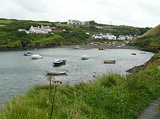
English: Abercastle is a village in the Welsh language speaking area of Pembrokeshire, south-west Wales. Abercastle comprises a working harbour which is managed by Abercastle Boat Owners Association. Nearby villages include Trefin, Llanrhian Porthgain, Mathry, Square and Compass, Penparc and Croesgoch.
Media in category "Abercastle"
The following 68 files are in this category, out of 68 total.
-
Aber Yw - geograph.org.uk - 5405047.jpg 3,264 × 2,448; 2.82 MB
-
Abercastell village - geograph.org.uk - 917243.jpg 640 × 480; 83 KB
-
Abercastell, lobsters and lime - geograph.org.uk - 917228.jpg 640 × 480; 73 KB
-
Abercastle (cropped).JPG 3,072 × 439; 913 KB
-
Abercastle - geograph.org.uk - 3390288.jpg 720 × 330; 56 KB
-
Abercastle at low tide - geograph.org.uk - 932546.jpg 640 × 425; 86 KB
-
Abercastle bay - geograph.org.uk - 1332820.jpg 640 × 425; 108 KB
-
Abercastle Bay.jpg 640 × 480; 41 KB
-
Abercastle mill - geograph.org.uk - 2022727.jpg 800 × 600; 139 KB
-
Abercastle Seal - geograph.org.uk - 946051.jpg 640 × 480; 110 KB
-
Abercastle.JPG 3,072 × 2,304; 4.49 MB
-
Alfred Johnson plaque.jpg 456 × 327; 57 KB
-
Coast Path to Abercastle - geograph.org.uk - 3390319.jpg 720 × 230; 33 KB
-
Cormorants (or shags) below Pen Morfa - geograph.org.uk - 758136.jpg 640 × 497; 125 KB
-
Cwm Badau-Bay of boats, Abercastle - geograph.org.uk - 917255.jpg 640 × 480; 76 KB
-
Cychod pysgota, Abercastell - Fishing boats, Abercastle - geograph.org.uk - 4322776.jpg 3,264 × 2,448; 3.71 MB
-
Dusk at Abercastle - Moorings - panoramio.jpg 1,600 × 1,200; 412 KB
-
Entrance to the bay - geograph.org.uk - 2315765.jpg 640 × 406; 104 KB
-
Fishing boats at Abercastle - geograph.org.uk - 67830.jpg 640 × 433; 75 KB
-
Fishing boats at Abercastle.JPG 3,072 × 2,304; 4.29 MB
-
Furthest point of Ynys y Castell - geograph.org.uk - 2022784.jpg 800 × 600; 136 KB
-
Pembrokeshire coast near Abercastell and Pwllstrodur.jpg 8,064 × 6,048; 12.77 MB
-
Pwllstrodur - geograph.org.uk - 53829.jpg 640 × 480; 115 KB
-
The Cliffs at Pwll Whiting - geograph.org.uk - 3919941.jpg 1,024 × 768; 434 KB
-
The entrance to the bay - geograph.org.uk - 2018024.jpg 800 × 600; 135 KB
-
Trwyn Llwynog - geograph.org.uk - 53833.jpg 640 × 480; 141 KB
-
Ynys y Castell, Abercastle - geograph.org.uk - 4577387.jpg 5,783 × 3,590; 2.85 MB
-
Abercastell - across the vale - geograph.org.uk - 1472903.jpg 640 × 480; 59 KB
-
Abercastle - geograph.org.uk - 15146.jpg 640 × 429; 52 KB
-
Brown corduroy - geograph.org.uk - 421575.jpg 640 × 480; 171 KB
-
Cottages - Abercastle - geograph.org.uk - 410114.jpg 640 × 480; 84 KB
-
Geese on reservoir - geograph.org.uk - 421571.jpg 640 × 480; 141 KB
-
Islands and arches - geograph.org.uk - 18604.jpg 640 × 480; 61 KB
-
Low reservoir - geograph.org.uk - 420990.jpg 640 × 480; 126 KB
-
Penmorfa - geograph.org.uk - 54036.jpg 640 × 489; 65 KB
-
Pwllstrodur - geograph.org.uk - 410108.jpg 640 × 480; 125 KB
-
Treacherous coastline - geograph.org.uk - 410117.jpg 640 × 480; 104 KB


