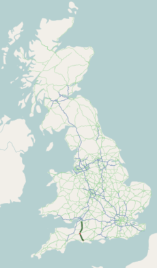
Category:A37 road (England)
Jump to navigation
Jump to search
road in England | |||||
| Upload media | |||||
| Instance of | |||||
|---|---|---|---|---|---|
| Location | Somerset, South West England, England | ||||
| Transport network |
| ||||
| Length |
| ||||
 | |||||
Media in category "A37 road (England)"
The following 71 files are in this category, out of 71 total.
-
A37 & B3147.jpg 3,264 × 2,448; 741 KB
-
A37 (UK Road).png 234 × 407; 13 KB
-
A37 - geograph.org.uk - 252815.jpg 640 × 480; 79 KB
-
A37 - geograph.org.uk - 252817.jpg 640 × 480; 101 KB
-
A37 - geograph.org.uk - 252819.jpg 640 × 480; 124 KB
-
A37 - geograph.org.uk - 346484.jpg 640 × 480; 98 KB
-
A37 almost at the top of Wraxall Hill - geograph.org.uk - 252818.jpg 640 × 480; 109 KB
-
A37 at Belluton, top of Pensford Hill - geograph.org.uk - 1360187.jpg 640 × 463; 112 KB
-
A37 at Cannards Grave.jpg 3,264 × 2,448; 889 KB
-
A37 at Farrington Gurney.jpg 3,264 × 2,448; 939 KB
-
A37 at Grimstone (just outside of Dorchester).jpg 3,264 × 2,448; 752 KB
-
A37 at Ston Easton.jpg 3,264 × 2,448; 995 KB
-
A37 at Strapestone - geograph.org.uk - 137548.jpg 640 × 480; 122 KB
-
A37 at Wrackleford - geograph.org.uk - 550512.jpg 640 × 480; 86 KB
-
A37 Bath Road.jpg 3,264 × 2,448; 1,014 KB
-
A37 Breakfast at Farrington Gurney - geograph.org.uk - 1605416.jpg 640 × 478; 152 KB
-
A37 Dorchester Road.jpg 3,264 × 2,448; 970 KB
-
A37 Huxham turn off - geograph.org.uk - 1504529.jpg 640 × 480; 274 KB
-
A37 Kilver Street.jpg 3,264 × 2,448; 962 KB
-
A37 looking north at Gurney Slade - geograph.org.uk - 1254033.jpg 640 × 467; 132 KB
-
A37 looking south at Gurney Slade - geograph.org.uk - 1254236.jpg 640 × 530; 175 KB
-
A37 looking south, top of Hursley Hill - geograph.org.uk - 1243016.jpg 640 × 488; 151 KB
-
A37 near Barwick.jpg 3,264 × 2,448; 812 KB
-
A37 near Binegar.jpg 3,264 × 2,448; 1.07 MB
-
A37 Near Huxam Green - geograph.org.uk - 1504505.jpg 640 × 480; 203 KB
-
A37 south towards Belluton - geograph.org.uk - 482660.jpg 640 × 480; 146 KB
-
A37 Whitstone Road.jpg 3,264 × 2,448; 919 KB
-
A37 Yeovil to Dorchester road - geograph.org.uk - 691733.jpg 640 × 480; 116 KB
-
A37.jpg 3,264 × 2,448; 621 KB
-
Abandoned Car in Floodwater - geograph.org.uk - 1158977.jpg 640 × 390; 75 KB
-
Approaching a roundabout on A37.jpg 3,264 × 2,448; 788 KB
-
Approaching Cannards Grave Roundabout.jpg 3,264 × 2,448; 811 KB
-
Approaching Wraxall - geograph.org.uk - 569531.jpg 640 × 480; 67 KB
-
Banktotterdown.JPG 2,341 × 1,917; 1.01 MB
-
County boundary stone - geograph.org.uk - 2812077.jpg 1,704 × 2,304; 2.02 MB
-
Dorchester Bypass - geograph.org.uk - 1490503.jpg 640 × 480; 70 KB
-
Flooded A37 at Ash Hill - geograph.org.uk - 1158978.jpg 640 × 428; 66 KB
-
Flooded A37 near Stratton - geograph.org.uk - 1158976.jpg 640 × 428; 80 KB
-
Flooded Road near Bradford Peverell - geograph.org.uk - 1158981.jpg 640 × 449; 68 KB
-
Flooded Road near Stratton - geograph.org.uk - 1158980.jpg 640 × 425; 81 KB
-
Grimstone geograph-3583273-by-Ben-Brooksbank.jpg 2,348 × 1,370; 3.4 MB
-
Grimstone, postbox No. DT2 13 - geograph.org.uk - 1382418.jpg 640 × 480; 114 KB
-
Knowlechurch.jpg 480 × 640; 111 KB
-
Leaving the A37.jpg 3,264 × 2,448; 1.81 MB
-
Memorial to Joanna Loving, Wrackleford. - geograph.org.uk - 794182.jpg 640 × 426; 119 KB
-
Old Milepost by the A37, Beard Hill, Pilton Parish (geograph 6045080).jpg 718 × 1,050; 130 KB
-
Old Milepost by the A37, Bristol Road, Ashwick parish (geograph 6061448).jpg 879 × 1,318; 186 KB
-
Old Milepost by the A37, Ston Easton parish (geograph 6048384).jpg 665 × 922; 106 KB
-
Old Milepost, A37, Bath Road, North of Shepton Mallet (geograph 6044224).jpg 879 × 1,350; 200 KB
-
Road Junction near Grimstone - geograph.org.uk - 895188.jpg 640 × 426; 83 KB
-
The A37 at Temple Cloud - geograph.org.uk - 1084282.jpg 640 × 472; 189 KB
-
The A37 at Wardon Hill - geograph.org.uk - 1145772.jpg 640 × 415; 64 KB
-
The A37, Break Heart Hill - geograph.org.uk - 908371.jpg 640 × 480; 137 KB
-
The George Inn - geograph.org.uk - 2869992.jpg 640 × 477; 89 KB
-
The George Inn, Gurney Slade - geograph.org.uk - 5055834.jpg 1,600 × 1,066; 638 KB
-
The George, Gurney Slade - geograph.org.uk - 6069640.jpg 3,296 × 2,472; 3.36 MB
-
Threelamps.JPG 1,334 × 2,726; 857 KB
-
UK road A37.PNG 568 × 184; 6 KB
-
UK road A37.svg 387 × 191; 2 KB
-
Whistle Bridge on A37 Dorchester Road - geograph.org.uk - 554968.jpg 640 × 480; 116 KB
-
A37 - The Old Mendip Inn - geograph.org.uk - 137661.jpg 640 × 480; 72 KB
-
A37 at White Cross - geograph.org.uk - 1087682.jpg 640 × 481; 162 KB


