Category:A24 road (England)
Jump to navigation
Jump to search
major road in England | |||||
| Upload media | |||||
| Instance of | |||||
|---|---|---|---|---|---|
| Location | |||||
| Transport network |
| ||||
| Connects with | |||||
| Length |
| ||||
| Terminus | |||||
 | |||||
Subcategories
This category has the following 5 subcategories, out of 5 total.
D
L
M
Media in category "A24 road (England)"
The following 72 files are in this category, out of 72 total.
-
A24 - speed camera on Ewell Bypass - geograph.org.uk - 4128868.jpg 640 × 428; 107 KB
-
A24 - traffic lights on Ewell bypass - geograph.org.uk - 4128856.jpg 640 × 428; 86 KB
-
A24 at the junction with The Warren - geograph.org.uk - 60222.jpg 640 × 480; 120 KB
-
A24 Near Dorking, Surrey - geograph.org.uk - 1503947.jpg 640 × 428; 94 KB
-
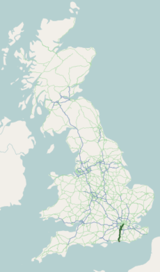
A24 road map.png 250 × 425; 48 KB
-
A24 Services - geograph.org.uk - 52403.jpg 640 × 480; 132 KB
-
A24 southbound carriageway - geograph.org.uk - 1766722.jpg 2,048 × 1,536; 683 KB
-
A24 Through the Mole Gap - geograph.org.uk - 971701.jpg 640 × 480; 101 KB
-
A24 Washington by pass passes through cutting - geograph.org.uk - 811135.jpg 2,048 × 1,536; 666 KB
-
A24, Broadbridge Heath - geograph.org.uk - 119388.jpg 640 × 480; 33 KB
-
Ashtead town centre - geograph.org.uk - 1274037.jpg 640 × 480; 65 KB
-
Bridge over the A24 - geograph.org.uk - 1002564.jpg 640 × 479; 123 KB
-
Bridge over the A24 - geograph.org.uk - 1003436.jpg 640 × 479; 56 KB
-
Bus stop on the A 24 southbound - geograph.org.uk - 1513616.jpg 640 × 480; 102 KB
-
Dorking A24 - geograph.org.uk - 289160.jpg 2,848 × 2,136; 2.77 MB
-
Dorking Road (A24) - geograph.org.uk - 56895.jpg 640 × 480; 86 KB
-
Dorking Road Epsom - geograph.org.uk - 2260339.jpg 1,600 × 1,200; 604 KB
-
Dorking Road, Epsom - geograph.org.uk - 2195115.jpg 4,320 × 3,240; 4.02 MB
-
East Street, Epsom - geograph.org.uk - 1879193.jpg 640 × 408; 141 KB
-
East Street, Epsom - geograph.org.uk - 2560038.jpg 3,872 × 2,592; 4.82 MB
-
East Street, Epsom - geograph.org.uk - 2983704.jpg 800 × 600; 138 KB
-
Epsom High Street - geograph.org.uk - 82242.jpg 640 × 480; 96 KB
-
Epsom Road, Ewell - geograph.org.uk - 1879205.jpg 640 × 421; 189 KB
-
Epsom Road, Ewell - geograph.org.uk - 2195100.jpg 4,320 × 3,240; 4.62 MB
-
Epsom Road, Ewell - geograph.org.uk - 2195106.jpg 4,320 × 3,240; 4.45 MB
-
Ewell by-pass at London Road - geograph.org.uk - 2983728.jpg 800 × 600; 81 KB
-
Farthings Hill Interchange - geograph.org.uk - 237858.jpg 640 × 323; 202 KB
-
Footbridge over the A24 - geograph.org.uk - 396638.jpg 640 × 487; 55 KB
-
High Street, Epsom - geograph.org.uk - 2559957.jpg 3,872 × 2,592; 4.65 MB
-
Junction of A24 and A240, Ewell - geograph.org.uk - 28664.jpg 640 × 480; 89 KB
-
London Road looking towards London - geograph.org.uk - 2556403.jpg 3,872 × 2,592; 4.69 MB
-
London Road near Stoneleigh - geograph.org.uk - 2556391.jpg 3,872 × 2,592; 5.03 MB
-
London Road, North Cheam - geograph.org.uk - 2983733.jpg 800 × 600; 78 KB
-
London Road, Stoneleigh - geograph.org.uk - 1879253.jpg 640 × 424; 200 KB
-
London Road, Stoneleigh - geograph.org.uk - 2556459.jpg 3,872 × 2,592; 4.78 MB
-
Mast next to the A24 S of Southwater - geograph.org.uk - 1417136.jpg 640 × 480; 109 KB
-
Mickleham Bends - geograph.org.uk - 198264.jpg 480 × 640; 160 KB
-
Mickleham bypass (A24) - geograph.org.uk - 56892.jpg 640 × 480; 96 KB
-
Quiet moment on A24 - geograph.org.uk - 1765979.jpg 2,048 × 1,536; 672 KB
-
Road, cycle path and footpath on A24 - geograph.org.uk - 1526864.jpg 640 × 480; 79 KB
-
Subway under the A24 - geograph.org.uk - 328590.jpg 480 × 640; 141 KB
-
Swanworth Farm - geograph.org.uk - 686008.jpg 640 × 480; 97 KB
-
The A24 - geograph.org.uk - 4892909.jpg 640 × 332; 65 KB
-
The A24 heading south to Worthing - geograph.org.uk - 1319501.jpg 640 × 480; 89 KB
-
The Ewell Bypass - geograph.org.uk - 2558479.jpg 3,872 × 2,592; 4.49 MB
-
The Street, Ashtead (view NE) - geograph.org.uk - 430355.jpg 640 × 474; 61 KB
-
The Street, Ashtead (view SW) - geograph.org.uk - 430356.jpg 640 × 410; 55 KB
-
The Wise Old Owl, Kingsfold. - geograph.org.uk - 185548.jpg 640 × 349; 84 KB
-
UK road A24.PNG 568 × 184; 6 KB
-
UK road A24.svg 387 × 191; 2 KB
-
Upper Tooting Rd, A24 - geograph.org.uk - 3638129.jpg 640 × 430; 67 KB
-
Upper Tooting Rd, A24 - geograph.org.uk - 3644638.jpg 640 × 430; 70 KB
-
Mickleham Bends A24 Autumn 2006 - geograph.org.uk - 344110.jpg 640 × 480; 114 KB
-
North Downs Way - geograph.org.uk - 256295.jpg 640 × 493; 162 KB


