Category:2012 maps of India
Jump to navigation
Jump to search
English: 2012 maps made in India or from India or showing history of India
Media in category "2012 maps of India"
The following 5 files are in this category, out of 5 total.
-
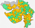 Gujarat Election 2012.png 592 × 466; 179 KB
-
 India roadway map.svg 1,639 × 1,852; 1.11 MB
-
 NWS-NOAA South Asia Extreme minimum temperature.gif 612 × 792; 54 KB
-
 Tamil Nadu and Kerala Openstreetmap Atlas.png 11,023 × 12,401; 15.95 MB
-
 Telugu speakers in India.png 2,000 × 2,334; 426 KB


