Category:1977 maps of Africa
Jump to navigation
Jump to search
Temperate regions: North America · South America · Africa · Europe · Asia · Oceania – Polar regions: – Other regions:
| ← 1970 1971 1972 1973 1974 1975 1976 1977 1978 1979 → |
Subcategories
This category has the following 9 subcategories, out of 9 total.
A
- 1977 maps of Angola (2 F)
B
- 1977 maps of Botswana (1 F)
C
- 1977 maps of Chad (2 F)
D
- 1977 maps of Djibouti (3 F)
E
- 1977 maps of Ethiopia (5 F)
K
- 1977 maps of Kenya (4 F)
S
- 1977 maps of Sierra Leone (1 F)
- 1977 maps of South Africa (2 F)
T
- 1977 maps of Tunisia (2 F)
Media in category "1977 maps of Africa"
The following 16 files are in this category, out of 16 total.
-
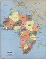
 Africa. LOC 79692035.jpg 13,463 × 17,200; 23.18 MB
-
 Africa. LOC 79692035.tif 13,463 × 17,200; 662.51 MB
-
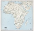
 Africa. LOC 79692110.jpg 10,504 × 9,540; 10.92 MB
-
 Africa. LOC 79692110.tif 10,504 × 9,540; 286.7 MB
-
 Africa. LOC 97687549.jpg 3,176 × 4,224; 1.67 MB
-
 Africa. LOC 97687549.tif 3,176 × 4,224; 38.38 MB
-
 Benin, administrative divisions. LOC 94686114.jpg 2,414 × 3,525; 1.23 MB
-
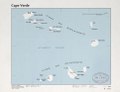
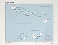 Cape Verde. LOC 80694141.jpg 4,143 × 3,171; 1.44 MB
-
 Cape Verde. LOC 80694141.tif 4,143 × 3,171; 37.59 MB
-
 Central African Empire. LOC 98686709.jpg 4,152 × 3,175; 1.5 MB
-
 Central African Empire. LOC 98686709.tif 4,152 × 3,175; 37.72 MB
-
 Sierra Leone. LOC 97687571.tif 3,163 × 4,158; 37.63 MB
-
 Western Sahara. LOC 82691612.jpg 4,328 × 3,338; 1.23 MB
-
 Western Sahara. LOC 82691612.tif 4,328 × 3,338; 41.33 MB
-
 Zanzibar and Pemba. LOC 2005631414.jpg 2,521 × 3,252; 716 KB
-
 Zanzibar and Pemba. LOC 2005631414.tif 2,521 × 3,252; 23.46 MB


