Category:1969 in Omagh
Jump to navigation
Jump to search
The town of Omagh in 1969.
Media in category "1969 in Omagh"
The following 19 files are in this category, out of 19 total.
-
 A lost cause, Omagh - geograph.org.uk - 1081358.jpg 640 × 389; 36 KB
-
 Campsie Playing Fields flooded - geograph.org.uk - 1081366.jpg 640 × 394; 39 KB
-
-
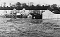
 Flooding at Campsie, Omagh - geograph.org.uk - 152145.jpg 640 × 442; 68 KB
-
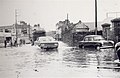 Flooding at Dublin Road, Omagh - geograph.org.uk - 152148.jpg 640 × 417; 39 KB
-
 Floods at Campsie Road, Omagh - geograph.org.uk - 1081373.jpg 412 × 640; 57 KB
-
 Floods at Old Dromore Road, Omagh - geograph.org.uk - 1080597.jpg 640 × 410; 42 KB
-
 Floods at Old Dromore Road, Omagh - geograph.org.uk - 1080599.jpg 640 × 390; 33 KB
-
 Floods at Sedan Avenue, Omagh - geograph.org.uk - 1081333.jpg 640 × 404; 50 KB
-

-

-
 Omagh Flooding (1969).jpg 640 × 414; 48 KB
-
 Omagh floods, 1969 - geograph.org.uk - 1081311.jpg 640 × 396; 32 KB
-
 Reflections, County Hall, Omagh - geograph.org.uk - 1081367.jpg 640 × 393; 48 KB
-
 River bank burst, Omagh - geograph.org.uk - 1081349.jpg 640 × 401; 55 KB
-

-
 Stranded at Dublin Road, Omagh - geograph.org.uk - 1081348.jpg 640 × 406; 37 KB
-
 The Strule about to burst, Omagh - geograph.org.uk - 1081338.jpg 640 × 395; 36 KB
-


.jpg)


