Category:1900s maps of the Iberian Peninsula
Jump to navigation
Jump to search
| 20th-century maps of the Iberian Peninsula: ← 1900s 1910s 1920s 1930s 1940s 1950s 1960s 1970s 1980s 1990s → |
Subcategories
This category has the following 2 subcategories, out of 2 total.
P
S
Media in category "1900s maps of the Iberian Peninsula"
The following 14 files are in this category, out of 14 total.
-

-
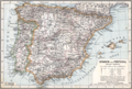 Spanien Portugal 1905.png 2,000 × 1,346; 1.71 MB
-
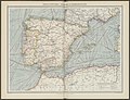 The Harmsworth atlas and Gazetter 1908 (135849368).jpg 12,514 × 9,570; 120.89 MB
-
 The Harmsworth atlas and Gazetter 1908 (135849402).jpg 9,584 × 12,453; 141.5 MB
-

-
 Brockhaus and Efron Encyclopedic Dictionary b25 400-0.jpg 3,379 × 2,552; 2.95 MB
-
 D469- N° 287. Espagne physique. -liv3-ch4.png 1,420 × 1,583; 370 KB
-

-
 Map of Spain & Portugal.jpg 3,315 × 2,946; 2.35 MB
-
 Mapa de España y Portugal... - por F. Noriega - btv1b530603453.jpg 10,824 × 8,327; 16.82 MB
-
 Mapa General España, Portugal Y Ex-Posesiones Españolas - 1, Acervo do Museu Paulista da USP.jpg 7,216 × 5,412; 27.12 MB
-
-
 Spain and Portugal- handbook for travellers (1901) (14753556636).jpg 4,244 × 3,409; 4.34 MB
-
 A.L. Hickmann's geographisch-statistischer universel-Taschen-Atlas. 1900 (80112515).jpg 5,293 × 4,307; 4.75 MB
_(14779589362).jpg)

.jpg)
.jpg)


_(14753556636).jpg)
.jpg)