
Category:1900s maps of London
Media in category "1900s maps of London"
The following 28 files are in this category, out of 28 total.
-
 1900 Bacon Pocket Map of London, England - Geographicus - London-bacon-1900.jpg 5,000 × 4,454; 8.05 MB
-
 Europe and other continents (1901) (14783555403).jpg 1,616 × 2,406; 1.02 MB
-
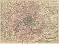 Stanford Map, 1901, Outer London Map.jpg 10,035 × 7,531; 84.03 MB
-
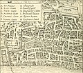
 Edward Stanford 1904 (detail).jpg 2,827 × 1,534; 322 KB
-
 Edward Stanford 1904.jpg 2,830 × 1,536; 818 KB
-
 London, Stanford's two-inch map 1906 Wellcome V0013882.jpg 3,344 × 2,236; 4.05 MB
-
 London; Stanford's two-inch map. Coloured lithograph, n.d. ( Wellcome V0013884.jpg 2,994 × 2,891; 5.4 MB
-
 London; Stanford's two-inch map. Coloured lithograph, n.d. ( Wellcome V0013886.jpg 3,004 × 3,008; 5.68 MB
-
 Brief guide to London (1908) (14776382024).jpg 2,856 × 2,284; 665 KB
-
 The Harmsworth atlas and Gazetter 1908 (135848766).jpg 12,484 × 9,575; 133.93 MB
-
 A wanderer in London (1906) (14743527276).jpg 1,602 × 1,228; 370 KB
-
 A wanderer in London (1906) (14764176294).jpg 1,598 × 410; 106 KB
-
 A wanderer in London (1906) (14766208632).jpg 1,604 × 1,412; 468 KB
-
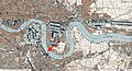
 Admiralty Chart No 3337 River Thames London Bridge to Woolwich, Published 1903.jpg 18,805 × 11,282; 88.37 MB
-
 An introduction to English literature (1902) (14741238846).jpg 2,452 × 2,132; 1.09 MB
-
 An introduction to English literature (1902) (14761879904).jpg 2,568 × 3,252; 1.21 MB
-
 D306- N° 475. Londres et le genre humain. - Liv4-Ch01.png 1,436 × 1,495; 69 KB
-
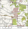 Eltham map 1908.png 1,597 × 1,626; 3.58 MB
-
 Extract of 1900 map showing Shepherd's Bush Green.png 393 × 489; 150 KB
-
 Jewish East London (1901).jpg 9,225 × 7,029; 16.65 MB
-
 Leyton Urban District Council Act 1904 map.jpg 600 × 348; 70 KB
-
 London; Stanford's two-inch map. Coloured lithograph, n.d. ( Wellcome V0013883.jpg 2,995 × 3,004; 5.12 MB
-
 London; Stanford's two-inch map. Coloured lithograph, n.d. ( Wellcome V0013885.jpg 3,083 × 2,511; 4.81 MB
-
 London; Stanford's two-inch map. Coloured lithograph, n.d. ( Wellcome V0013889.jpg 2,996 × 3,004; 5.1 MB
-
 Our own islands; an elementary study in geography (1907) (14742625146).jpg 2,864 × 1,894; 680 KB
-
 Spa Road station map 1900.png 463 × 406; 158 KB
-
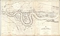
 Thames wharf map 1905 London Bridge to Limehouse.jpg 4,096 × 2,304; 860 KB
-
 Thames wharf map 1905.jpg 17,202 × 4,622; 5.82 MB

_(14783555403).jpg)

.jpg)


_(14776382024).jpg)
.jpg)
_(14743527276).jpg)
_(14766208632).jpg)

_(14741238846).jpg)
_(14761879904).jpg)


.jpg)


_(14742625146).jpg)


_(14764176294).jpg)