Category:1878 maps of Connecticut
Jump to navigation
Jump to search
States of the United States: California · Colorado · Connecticut · Illinois · Maryland · Michigan · New York · Pennsylvania · Texas
| 1875 1878 |
Media in category "1878 maps of Connecticut"
The following 9 files are in this category, out of 9 total.
-
 New Hartford, Conn. (2674630050).jpg 2,000 × 1,582; 3.23 MB
-
 View of Bristol, Conn. (2675964740).jpg 2,000 × 1,703; 3.16 MB
-
 View of Collinsville, Conn. (2675965732).jpg 2,000 × 1,569; 2.47 MB
-
 View of Collinsville, Conn. LOC 2008624184.jpg 9,808 × 8,124; 12.56 MB
-
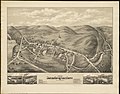
 View of New Canaan, Conn. (2674639778).jpg 2,000 × 1,585; 2.85 MB
-
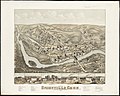
 View of South Coventry, Conn. (2674665096).jpg 2,000 × 1,572; 2.66 MB
-
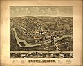
 View of Unionville, Conn. (2673848883).jpg 2,000 × 1,594; 2.42 MB
-
 View of Unionville, Conn. LOC 88694131.jpg 8,432 × 6,656; 10.75 MB
-
 View of Westport, Conn. (2673813035).jpg 2,000 × 1,581; 2.06 MB
.jpg)
.jpg)
.jpg)

.jpg)
.jpg)
.jpg)

.jpg)