Category:1870s maps of Georgia (U.S. state)
Jump to navigation
Jump to search
States of the United States: Alabama · Alaska · Arizona · Arkansas · California · Colorado · Connecticut · Delaware · Florida · Georgia · Hawaii · Idaho · Illinois · Indiana · Iowa · Kansas · Kentucky · Louisiana · Maine · Maryland · Massachusetts · Michigan · Minnesota · Mississippi · Missouri · Montana · Nebraska · Nevada · New Hampshire · New Jersey · New Mexico · New York · North Carolina · North Dakota · Ohio · Oklahoma · Oregon · Pennsylvania · Rhode Island · South Carolina · South Dakota · Tennessee · Texas · Utah · Vermont · Virginia · Washington · West Virginia · Wisconsin · Wyoming – Washington, D.C.
Puerto Rico
Puerto Rico
Media in category "1870s maps of Georgia (U.S. state)"
The following 11 files are in this category, out of 11 total.
-

-

-

-
 5 OCT 1879 Decatur, GA Map, DeKalb Historical Society.jpg 750 × 607; 180 KB
-
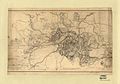 Atlanta 19 July- 26 August 1864.jpeg 1,742 × 1,215; 384 KB
-
 Map of Chatham County, state of Georgia LOC 2012593661.jpg 12,138 × 15,239; 28.54 MB
-
 Map of Chatham County, state of Georgia LOC 2012593661.tif 12,138 × 15,239; 529.21 MB
-
 Map of Chatham County, state of Georgia LOC 2012593662.jpg 3,211 × 4,489; 2.84 MB
-
 Map of Chatham County, state of Georgia LOC 2012593662.tif 3,211 × 4,489; 41.24 MB
-

-
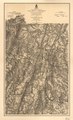 Map(s) illustrating the military operations of the Atlanta campaign ... 1864 LOC 2008628278.tif 8,984 × 14,808; 380.62 MB
%27_(11100286665).jpg)
.jpg)


_illustrating_the_military_operations_of_the_Atlanta_campaign_..._1864_LOC_2008628278.jpg)