Category:1770s maps of the Caribbean
Jump to navigation
Jump to search
Subcategories
This category has the following 6 subcategories, out of 6 total.
Media in category "1770s maps of the Caribbean"
The following 24 files are in this category, out of 24 total.
-
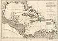
 (Map showing Caribbean area including West Indies and Gulf of Mexico. LOC 75695814.tif 12,731 × 7,272; 264.87 MB
-
 Histoire des deux Indes-Atlas-d42-C23-Hayti-St Domingue.png 2,664 × 1,882; 1.26 MB
-

-

-

-
-

-
 A map of the Caribbee, Granadilles, and Virgin isles - btv1b5970881s.jpg 8,480 × 10,472; 9.43 MB
-
 AMH-7920-KB Map of the Caribbean.jpg 2,400 × 1,461; 724 KB
-
 Caribbean 1776.jpg 7,188 × 4,896; 4.61 MB
-

-
 Carte du golfe du Méxique, des isles et des pays adjacens. LOC 74692899.tif 7,655 × 5,171; 113.25 MB
-

-

-
 Histoire des deux Indes-Atlas-d41-C22-Golphe du Mexique.png 2,991 × 2,282; 1.88 MB
-

-
-

-

-

-

-

-

-
 West-Indies---Kitchin.jpg 3,585 × 2,237; 2.23 MB


_Robert_de_Vaugondy_G%C3%A9ographe_ord(inaire)_du..._-_btv1b550137444_(145_of_183).jpg)


.jpg)
_-_dress%C3%A9e_par_Bellin_en_1749_-_btv1b531032885.jpg)
_-_par_le_S._Bellin..._-_btv1b531032472.jpg)

.jpg)

_-_The_fourth_book._Describing_The_West-India_navigation,_from_Hudson%27s_Bay_to_the_River_Amazones._Particularly_delineating_The_Sea_Coasts,_Capes,_Headlands,_(14593422190).jpg)
_-_The_fourth_book._Describing_The_West-India_navigation,_from_Hudson%27s_Bay_to_the_River_Amazones._Particularly_delineating_The_Sea_Coasts,_Capes,_Headlands,_(14593597498).jpg)
_-_The_fourth_book._Describing_The_West-India_navigation,_from_Hudson%27s_Bay_to_the_River_Amazones._Particularly_delineating_The_Sea_Coasts,_Capes,_Headlands,_(14777787084).jpg)

