Category:Ökonomiegebäude (Mühlenstrasse 16, Stein am Rhein)
Jump to navigation
Jump to search
| Object location | | View all coordinates using: OpenStreetMap |
|---|
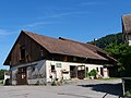
outbuilding of the former mill in Stein am Rhein in the canton of Schaffhausen, Switzerland  Ökonomiegebäude | |||||
| Upload media | |||||
| Instance of | |||||
|---|---|---|---|---|---|
| Part of | |||||
| Location | Stein am Rhein, Stein District, Schaffhausen, Switzerland | ||||
| Street address |
| ||||
| Heritage designation | |||||
 | |||||
Media in category "Ökonomiegebäude (Mühlenstrasse 16, Stein am Rhein)"
The following 2 files are in this category, out of 2 total.
-
 Obere Mühle Stein am Rhein P1030543.jpg 5,184 × 3,888; 9.34 MB
-
 Obere Mühle Stein am Rhein P1030598.jpg 5,184 × 3,888; 9.1 MB
