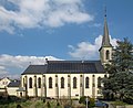
Category:Église Saint-Pierre (Useldange)
Jump to navigation
Jump to search
| Object location | | View all coordinates using: OpenStreetMap |
|---|
 | |||||
| Upload media | |||||
| Instance of | |||||
|---|---|---|---|---|---|
| Location |
| ||||
 | |||||
Media in category "Église Saint-Pierre (Useldange)"
The following 5 files are in this category, out of 5 total.
-
 Kierch Useldeng, Juli 2017-101.jpg 4,790 × 7,177; 22.66 MB
-
 Kierch Useldeng, Juli 2017-102.jpg 4,478 × 6,709; 29.62 MB
-
 Kirche Useldange 01.jpg 1,850 × 1,512; 1.73 MB
-
 Kirche Useldange 02.jpg 1,380 × 2,025; 1.59 MB
-
 Vue op Useldeng.JPG 3,651 × 2,041; 1.67 MB


