Aangepast Pakket
Overzicht
In de OsmAnd-applicatie kunt u veel aanpassingen maken en deze exporteren naar een .osf-bestand. Na het toevoegen van een beschrijving, afbeelding en icoon, worden deze aanpassingen een volledig onafhankelijke plugin. Deze plugin kan bevatten:
- Alle Profile Settings met een nieuw profiel.
- Specifieke set snelle acties en menu-indelingen voor Drawer en Context menu.
- Aangepaste offline kaart binnen de plugin of voorgesteld om te downloaden.
- Specifieke online routeringstypes en online kaarten.
Hoe te Creëren
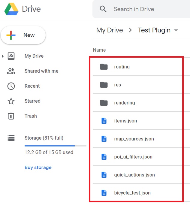
Het .osf bestand is een hernoemd ..zip bestand dat .json-bestanden en mappen bevat. Als voorbeeld kunt u onze voorbereide bestanden downloaden van Google Drive of een kant-en-klare plugin via deze link.
U kunt .json-bestanden aanpassen met behulp van OsmAnd's items.json-bestand, dat commando's bevat voor het importeren van .json-bestanden, .obf-bestanden, iconen en meer.
Mogelijk moet u lezen:
- Over het
.json-formaat. - Over text editors, waarmee u bestanden in JSON-formaat kunt openen en bewerken.
- Over de Sublime Text-editor, die in OsmAnd als referentie wordt gebruikt.
- U kunt uw code controleren in JSON Editor Online.
items.json
OsmAnd's items.json-bestand.
{
   "version":1,
   "items":[

      {
         "type":"PLUGIN",
         "pluginId":"test.plugin",
         "version" : 1,
         "icon": {
             "" : "@plugin-id.png"

         },
         "image": {
             "" :"@plugin-image.webp"
         },
         "name":{
            "":"Test Plugin",
            "ru":"Test Plugin: RU language"
         },
         "description":{
            "":"This package is a test package and displays test information.",
            "ru":"This package is a test package and displays test information. RU language."
         }
      },

      {
         "type":"RESOURCES",
         "pluginId":"test.plugin",
         "file":"res"
      },


      {
         "type":"DOWNLOADS",
         "pluginId":"test.plugin",
         "items":[
            {
               "path":"test",
               "name":{
                  "":"My offline maps",
                  "ru":"RU: My offline maps"
               },
               "icon":{
                  "":"ic_world_globe_dark"
               },
               "header-color":"#002E64",
               "description":{
                  "text":{
                     "":"This package is a collection of online and offline map sources of various types.",
                     "ru":"RU: This package is a collection of online and offline map sources of various types."
                  },
                  "button":[
                     {
                        "":"Telegram chat OsmAnd",
                        "url":"https:\/\/t.me\/OsmAndMaps"
                     }
                  ]
               }
            },
            {
               "scope-id":"offline-maps",
               "path":"test/Waterway",
               "header-color":"#002E64",
               "name":{
                  "":"Waterway",
                  "ru":"RU: waterway"
               },
               "icon":{
                  "":"ic_world_globe_dark"
               },
               "items":[
                  {
                     "name":{
                        "":"Offline Waterway map SA",
                        "ru":"RU: Offline Waterway map SA"
                     },
                     "filename":"waterway.obf.zip",
                     "type":"map",
                     "isHidden":"true",
                     "timestamp":1582994500,
                     "containerSize":28195301,
                     "contentSize":28195301,
                     "description":{
                        "text":{
                           "":"Zoom min: 0<br />Zoom max: 19<br />Countries: SA",
                           "ru":"RU: Zoom min: 0<br />Zoom max: 19<br />Countries: SA"
                        },
                        "image":[
                           "https://drive.google.com/uc?id=16HjUHsSWNgeQI0bmuup9ohpyrg6rWkHH&export=download"
                        ]
                     },
                     "downloadurl":"https://drive.google.com/uc?id=10iP2VZexHtHC0QLhACZ1QoEy-duNN5Wg&export=download",
                     "firstsubname":{
                        "":"Waterway",
                        "ru":"RU: Waterway"
                     },
                     "secondsubname":{
                        "":"",
                        "ru":""
                     }
                }
           ]
        }]
    },

      {
         "type":"PROFILE",
         "pluginId":"test.plugin",
         "file":"bicycle_test.json",
         "appMode":{
            "iconColor":"RED",
            "iconName":"ic_action_motorcycle_dark",
            "locIcon":"BENTLEY",
            "navIcon":"BENTLEY",
            "order":32,
            "parent":"bicycle",
            "stringKey":"bicycle_test",
            "userProfileName" : "Test Prof"
         },
         "prefs" : {
            "drawer_logo": { "" : "@logo.png"},
            "drawer_url" : { "" : "https://osmand.net"},
            "drawer_items" : { "hidden" : ["dashboard"], "order" : ["map_markers", "my_places", "search"] },
            "context_menu_items" : {},
            "configure_map_items" : {},
            "route_service":"OSMAND",
            "renderer":"test-rendering.render.xml",
            "routing_profile":"routing-test.xml/test-car"
        }
      },

      {
         "type":"FILE",
         "pluginId":"test.plugin",
         "subtype" : "rendering_style",
         "file":"\/rendering\/test-rendering.render.xml"
      },

      {
         "type":"FILE",
         "pluginId":"test.plugin",
         "subtype" : "routing_config",
         "file":"\/routing\/routing-test.xml"
      },

      {
         "type":"SUGGESTED_DOWNLOADS",
         "pluginId":"test.plugin",
         "comment-1" : "search-type are latlon (closest by latlon), worldregion (by boundaries if name matches worldRegion downloadName as we do for default types), by default natural order, limit finds first N elements",
         "comment-2" : "predefined scope-id are @type of indexes.xml map, srtm_map, road_map, wikimap, wikivoyage, hillshade, slope, fonts, voice, depth ",
         "comment-3" : "names filters ignore case by name.contains(filterName)",
         "items": [{
             "scope-id" : "test-downloads",
             "limit" : 1,
             "search-type" : "latlon"
         }, {
             "scope-id" : "road_map",
             "names" : [
                 "Poland_lesser-poland_europe_2.obf.zip", "netherlands_noord-holland_europe"]
         }, {
             "scope-id" : "wikimap",
             "search-type" : "worldregion"
         }]
      },

      {
         "type":"NAVIGATION_ICONS",
         "pluginId":"test.plugin",
         "items" : [{
            "locationIcon": {
                 "" : "@bentley-car.png"
            },
            "locationIconId": "BENTLEY",
            "navigationIcon": {
                 "" : "@bentley-car-moving.png"
            },
            "navigationIconId": "BENTLEY"
         }]
      },

      {
         "type":"QUICK_ACTIONS",
         "pluginId":"test.plugin",
         "items": [{
            "name": "Test quick action",
            "actionType": "osmbug.add",
            "params": "{\"dialog\":\"false\",\"message\":\"Message\"}"
          }]
      },

      {
         "type":"POI_UI_FILTERS",
         "pluginId":"test.plugin",
          "items": [{
                "name": "Test Search",
                "filterId": "test_search",
                "acceptedTypes": "{\"sustenance\":[\"bar\",\"alpine_hut\"]}"
            }]
      },

      {
         "type":"MAP_SOURCES",
         "pluginId":"test.plugin",
         "items": [{
            "sql": false,
            "name": "OsmAnd (test)",
            "minZoom": 1,
            "maxZoom": 19,
            "url": "https:\/\/tile.osmand.net\/hd\/{0}\/{1}\/{2}.png",
            "ellipsoid": false,
            "inverted_y": false,
            "timesupported": false,
            "expire": -1,
            "inversiveZoom": false,
            "ext": ".png",
            "tileSize": 512,
            "bitDensity": 8,
            "avgSize": 18000
        }]
      }
   ]
}
Import Types
Er zijn veel importtypes voor het OsmAnd items.JSON-bestand. Alle types zijn hier te vinden, en dit artikel beschrijft slechts enkele ervan.
Plugin Description
Om te beginnen, creëert en voegt u uw plugin toe aan items.JSON. Het eerste type import is "PLUGIN".
NOTE. U moet deze regel voor elk type aanmaken en toevoegen: "pluginId":"test.plugin", waarbij test.plugin de naam van uw pakket is.
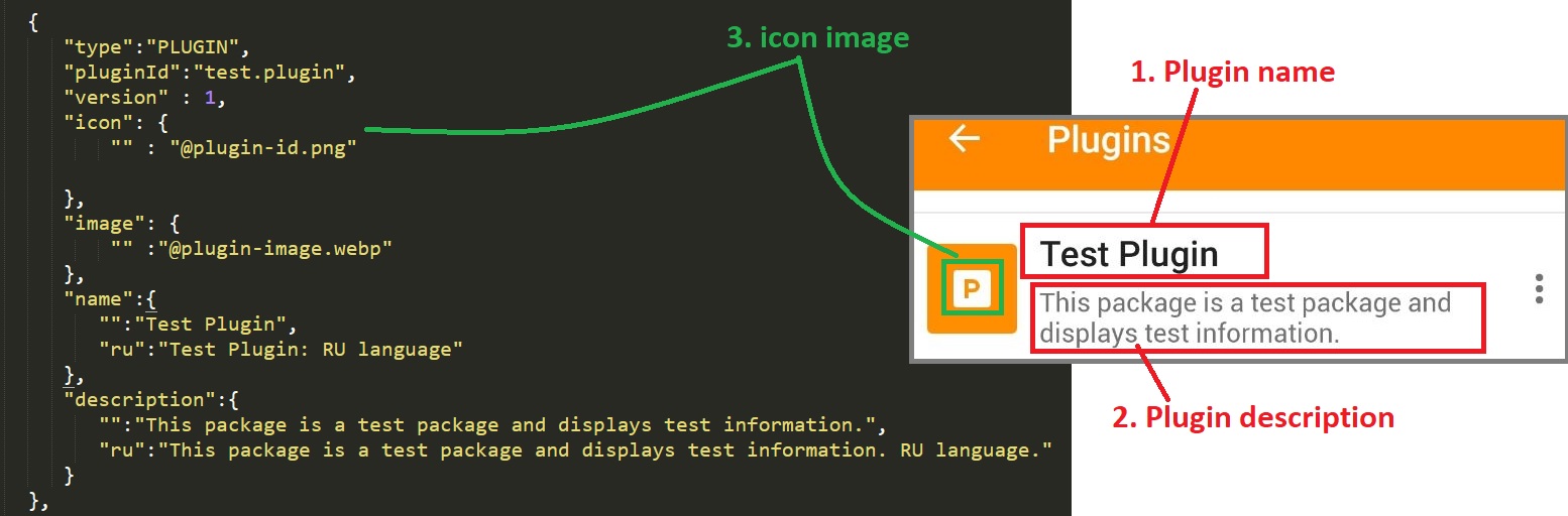
Plugin Images
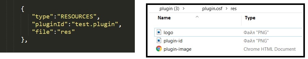
Om uw pluginafbeeldingen in OsmAnd te importeren, maakt u een map (in ons voorbeeld is dit de "res" map) waar de afbeeldingsbestanden worden opgeslagen. De naam van dit type is "RESOURCES".
Profiles
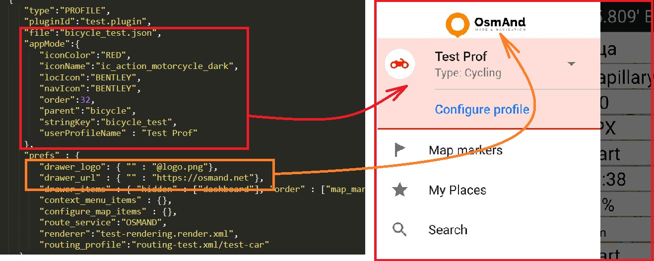
Met het type "PROFILE" kunt u een navigatieprofiel voor uw plugin toevoegen. U kunt alle informatie over uw navigatieprofiel vinden in het geëxporteerde JSON-bestand, waar u kunt lezen welke items.JSON-types zijn toegevoegd (“QUICK_ACTIONS”, “POI_UI_FILTERS”, “MAP_SOURCES” of andere). OPMERKING: Begin met het aanmaken van een navigatieprofiel met alle parameters. Exporteer hiervoor navigatieprofielen en kopieer de benodigde items van het navigatie profiles.osf (items.JSON)-bestand naar het PLUGIN.osf (items.JSON)-bestand.
Downloads
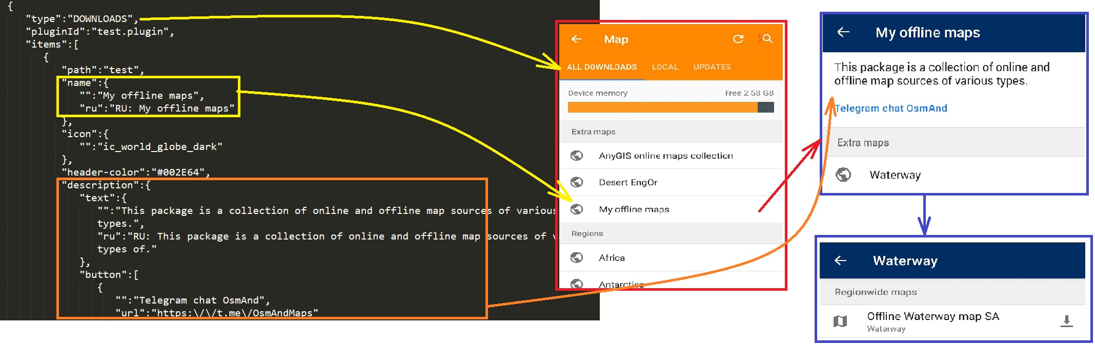
U kunt alle bestanden zoals SQLite, OBF, of lettertypen toevoegen om te downloaden met het type "DOWNLOADS". De belangrijkste types downloadbare bestanden zijn hier te vinden.
NOTE. De tag "isHidden":"true" (standaard is dit false) kan uw kaartgegevens verbergen voor Maps and Resources van OsmAnd. In "scope-id" kunt u alle benodigde informatie over de URL, naam, beschrijving en meer van uw bestand toevoegen.
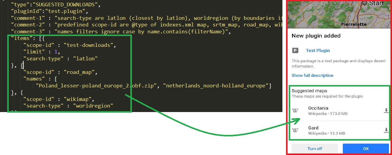
Suggested Downloads
In het type "SUGGESTED_DOWNLOADS" kunt u de kaarten downloaden die OsmAnd aanbiedt bij het importeren van een nieuwe plugin.
Files
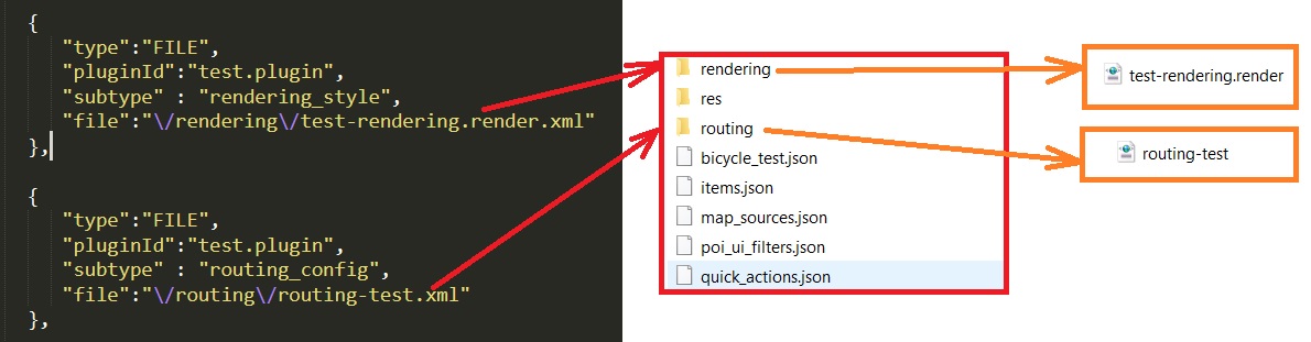
In het type "FILE" kunt u bestanden uit uw pluginmappen toevoegen aan OsmAnd-mappen, waarvan de "subtype" hier te vinden is. In het gegeven voorbeeld zijn de bestanden routing.xml en rendering.xml toegevoegd. U kunt lezen hoe u deze bestanden kunt maken via de links hier en hier.
Wanneer het items.JSON-bestand en alle bestanden in de map klaar zijn, kunt u ze in één document zippen. Daarna moet het .zip-bestand hernoemd worden naar .osf, en dan is uw PLUGIN.osf klaar om aan de OsmAnd-applicatie te worden toegevoegd.
Examples
U kunt enkele van de plugins bekijken die OsmAnd-gebruikers zelf hebben gemaakt:
- The USA Maps aangepaste plugin (PAD-US data, USFS paden en wegen, USFS recreatie).
- Anygis maps aangepaste plugin.
- Map Legend aangepaste plugin.
- UMP-PL Polen kaart aangepaste plugin.
- OsmAnd Rendering plugin aangepaste plugin.
- Outdoor Explorer aangepaste plugin.