File talk:G219边的果只岗日峰.jpg
Jump to navigation
Jump to search
果只岗日峰 Identification
[edit]

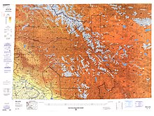
Regarding [1], I believe "果只岗日峰" ("Guozhi Gangri Feng") may refer to a 'Sumsti Gangri', which appears on this map. '果只岗日' appears on map.baidu.com. Neither 果只岗日 nor Sumsti Gangri, nor Sumsti, nor anything near 34°34'14.6"N 80°19'48.1"E appears in GEOnet. --Geographyinitiative (talk) 18:09, 27 May 2022 (UTC)
- The Chinese name of the peak is "果只岗日", you can find it on tianditu.gov.cn and Peakfinder when I first made the edit. At the time of that edit, I could not find the English transliteration, so "Guozhi Gangri" was an ad hoc translation by me, then Kautlya3 added it to OpenStreetMap.
- I did some more digging today, and found this webpage which indicates the Tibetan name as "སྒོ་བྲག་གངས་རི". Tibetan name can be transliterated using THL Simplified to Godrak Gangri, which is listed EKI's Tibetan name database.
- No clue about "Sumsti Gangri". --Voidvector (talk) 03:16, 30 May 2022 (UTC)