File:Zhuoshuixishiyitu.PNG
Jump to navigation
Jump to search

Size of this preview: 800 × 387 pixels. Other resolutions: 320 × 155 pixels | 950 × 460 pixels.
Original file (950 × 460 pixels, file size: 31 KB, MIME type: image/png)
Captions
Captions
Add a one-line explanation of what this file represents
Summary
[edit]
| Description |
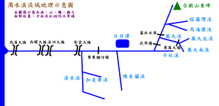
English: map with dam locators in Taiwan 中文:濁水溪流域地理示意圖 by mingwangx
本圖僅表示各溪、山、壩、橋之間的相對位置,方位及比例均不精確。 參考資料:林孟龍、王鑫著,《台灣的河流》、黃兆慧著《台灣的水庫》。 |
| Source | |
| Author | mingwangx |
Licensing
[edit]
I, the copyright holder of this work, hereby publish it under the following licenses:

|
Permission is granted to copy, distribute and/or modify this document under the terms of the GNU Free Documentation License, Version 1.2 or any later version published by the Free Software Foundation; with no Invariant Sections, no Front-Cover Texts, and no Back-Cover Texts. A copy of the license is included in the section entitled GNU Free Documentation License. |
| This file is licensed under the Creative Commons Attribution-Share Alike 3.0 Unported license. | ||
| ||
| This licensing tag was added to this file as part of the GFDL licensing update. |
This file is licensed under the Creative Commons Attribution-Share Alike 2.5 Generic, 2.0 Generic and 1.0 Generic license.
- You are free:
- to share – to copy, distribute and transmit the work
- to remix – to adapt the work
- Under the following conditions:
- attribution – You must give appropriate credit, provide a link to the license, and indicate if changes were made. You may do so in any reasonable manner, but not in any way that suggests the licensor endorses you or your use.
- share alike – If you remix, transform, or build upon the material, you must distribute your contributions under the same or compatible license as the original.
You may select the license of your choice.
File history
Click on a date/time to view the file as it appeared at that time.
| Date/Time | Thumbnail | Dimensions | User | Comment | |
|---|---|---|---|---|---|
| current | 09:31, 17 February 2006 | | 950 × 460 (31 KB) | Mingwangx (talk | contribs) | 濁水溪流域地理示意圖 by mingwangx 本圖僅表示各溪、山、壩、橋之間的相對位置,方位及比例均不精確。 參考資料:林孟龍、王鑫著,《台灣的河流》、黃兆慧著《台灣的水庫》。 |
| 09:19, 17 February 2006 |  | 950 × 460 (31 KB) | Mingwangx (talk | contribs) | 濁水溪流域地理示意圖 本圖僅表示各溪、山、壩、橋之間的相對位置,方位及比例均不精確。 參考資料:林孟龍、王鑫著,《台灣的河流》、黃兆慧著《台灣的水庫》。 |
You cannot overwrite this file.
File usage on Commons
The following page uses this file:
File usage on other wikis
The following other wikis use this file:
- Usage on zh.wikipedia.org