File:Zaniemyśl (gmina) location map.png
Jump to navigation
Jump to search

Size of this preview: 546 × 599 pixels. Other resolutions: 219 × 240 pixels | 586 × 643 pixels.
Original file (586 × 643 pixels, file size: 87 KB, MIME type: image/png)
Captions
Captions
Add a one-line explanation of what this file represents
| Description |
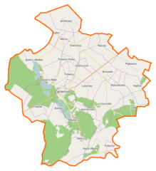
Polski: Mapa gminy Zaniemyśl, Polska
English: Map of Gmina Zaniemyśl, Poland |
|||||||||
| Date | ||||||||||
| Source | You may find a page on the OpenStreetMap wiki page for Zaniemyśl (gmina) | |||||||||
| Creator |
OpenStreetMap contributors OpenStreetMap contributors |
|||||||||
| Permission (Reusing this file) |
OpenStreetMap data is available under the Open Database License (details). Map tiles are licensed under the Creative Commons Attribution-ShareAlike 2.0 license (CC-BY-SA 2.0).
This file is licensed under the Creative Commons Attribution-Share Alike 2.0 Generic license.
|
|||||||||
| Geotemporal data | ||||||||||
| Bounding box |
|
|||||||||
| Georeferencing | If inappropriate please set warp_status = skip to hide. | |||||||||
File history
Click on a date/time to view the file as it appeared at that time.
| Date/Time | Thumbnail | Dimensions | User | Comment | |
|---|---|---|---|---|---|
| current | 12:07, 31 December 2014 | | 586 × 643 (87 KB) | VanWiel (talk | contribs) | {{OpenStreetMap | name = Zaniemyśl (gmina) | location = Zaniemyśl (gmina) | description = {{pl|Mapa gminy Zaniemyśl, Polska}} {{en|Map of Gmina Zaniemyśl, Poland}} | top = 52.2305 | bottom = 52.... |
You cannot overwrite this file.
File usage on Commons
There are no pages that use this file.
File usage on other wikis
The following other wikis use this file:
- Usage on fr.wikipedia.org
- Usage on pl.wikipedia.org
- Zaniemyśl (gmina)
- Czarnotki
- Jeziory Wielkie (Polska)
- Kępa Wielka
- Luboniec
- Lubonieczek
- Łękno (województwo wielkopolskie)
- Mądre
- Pigłowice
- Śnieciska
- Wyszakowo
- Zaniemyśl
- Bożydar (województwo wielkopolskie)
- Brzostek (województwo wielkopolskie)
- Płaczki (województwo wielkopolskie)
- Polesie (powiat średzki)
- Polwica (województwo wielkopolskie)
- Winna (województwo wielkopolskie)
- Zwola (województwo wielkopolskie)
- Jaszkowo (powiat średzki)
- Doliwiec Leśny
- Jeziory Małe (wieś)
- Kępa Mała
- Potachy
- Dobroczyn
- Dębice (województwo wielkopolskie)
- Majdany (Lubonieczek)
- Wyszakowskie Huby
- Ludwikowo (Wyszakowo)
- Kowalka (Zaniemyśl)
- Józefowo (powiat średzki)
- Konstantynowo (powiat średzki)
- Wyspa Edwarda
- Jezioro Raczyńskie
- Polwica-Huby
- Zofiówka (powiat średzki)
- Jeziorskie Huby
- Parafia Niepokalanego Serca Najświętszej Maryi Panny w Zaniemyślu
- Parafia św. Wawrzyńca w Zaniemyślu
- Zaniemyśl (stacja kolejowa)
- Jeziory Wielkie (jezioro)
- Jeziory Małe (jezioro)
- Łękno (jezioro)
- Kościół św. Wawrzyńca w Zaniemyślu
- Kościół Niepokalanego Serca Najświętszej Maryi Panny w Zaniemyślu
- Płaczki (przystanek kolejowy)
- Śnieciska (przystanek kolejowy)
- Polwica Wielkopolska
- Pigłowskie Huby
View more global usage of this file.
_location_map.png)
_location_map.png&oldid=507916302)