File:World Association of Girl Guides and Girl Scouts map.png
Jump to navigation
Jump to search
Size of this preview: 800 × 370 pixels. Other resolutions: 320 × 148 pixels | 640 × 296 pixels | 1,357 × 628 pixels.
Original file (1,357 × 628 pixels, file size: 56 KB, MIME type: image/png)
Captions
Captions
Add a one-line explanation of what this file represents
Summary
[edit]

|
File:World Association of Girl Guides and Girl Scouts map.svg is a vector version of this file. It should be used in place of this PNG file when not inferior.
File:World Association of Girl Guides and Girl Scouts map.png → File:World Association of Girl Guides and Girl Scouts map.svg
For more information, see Help:SVG. |
 |
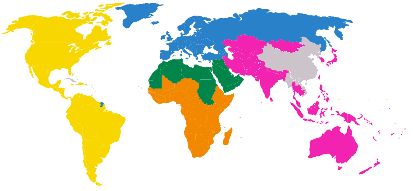
| Description | The map shows the regional divisions of the en:World Association of Girl Guides and Girl Scouts. Countries without Scouting or Guiding are marked in grey. |
| Date | 8 January 2006 (original upload date) |
| Source | Transfered from en.wikipedia Transfer was stated to be made by User:Rlevse. |
| Author | Kintetsubuffalo at en.wikipedia" |
| Permission (Reusing this file) |
GFDL-SELF-WITH-DISCLAIMERS; Released under the GNU Free Documentation License. |
Licensing
[edit]
I, the copyright holder of this work, hereby publish it under the following license:
| This file is licensed under the Creative Commons Attribution-Share Alike 3.0 Unported license. Subject to disclaimers. | ||
| ||
| This licensing tag was added to this file as part of the GFDL licensing update. |

|
Permission is granted to copy, distribute and/or modify this document under the terms of the GNU Free Documentation License, Version 1.2 or any later version published by the Free Software Foundation; with no Invariant Sections, no Front-Cover Texts, and no Back-Cover Texts. A copy of the license is included in the section entitled GNU Free Documentation License. Subject to disclaimers. |
See also
[edit]
- Image:WOSMMap-World.svg and Image:WOSMMap-World.png for the corresponding regions of the en:World Organization of the Scout Movement
- Image:BSA Region Map.svg for the corresponding regions of the en:Boy Scouts of America
Original upload log
[edit]
The original description page was here. All following user names refer to en.wikipedia.
- 2006-01-08 02:25 Kintetsubuffalo 1357×628×8 (65014 bytes) self
- 2006-01-08 02:23 Kintetsubuffalo 1357×628×8 (64953 bytes) self
File history
Click on a date/time to view the file as it appeared at that time.
| Date/Time | Thumbnail | Dimensions | User | Comment | |
|---|---|---|---|---|---|
| current | 15:18, 2 December 2010 | | 1,357 × 628 (56 KB) | Beao (talk | contribs) | Transparent. |
| 01:31, 17 December 2007 |  | 1,357 × 628 (63 KB) | Rlevse (talk | contribs) | {{Information |Description=The map shows the regional divisions of the en:World Association of Girl Guides and Girl Scouts. Countries without Scouting or Guiding are marked in grey. |Source=Transfered from [http://en.wikipedia.org en.wikipedia] Trans | |
| 16:44, 15 December 2007 |  | 800 × 370 (116 KB) | Rlevse (talk | contribs) | {{Information |Description={{en|The map shows the regional divisions of the en:World Association of Girl Guides and Girl Scouts. Countries without Scouting or Guiding are marked in grey. == See also == * en::Image:WOSMMap-World.png for the corr |
You cannot overwrite this file.
File usage on Commons
The following 2 pages use this file:
- User:Rlevse/gallery
- File:WAGGGSMap-World.png (file redirect)
File usage on other wikis
The following other wikis use this file: