File:Wola Ostrowiecka.GIF
Jump to navigation
Jump to search
Size of this preview: 800 × 483 pixels. Other resolutions: 320 × 193 pixels | 640 × 386 pixels | 860 × 519 pixels.
Original file (860 × 519 pixels, file size: 157 KB, MIME type: image/gif)
Captions
Captions
Add a one-line explanation of what this file represents
Summary
[edit]
| Description |
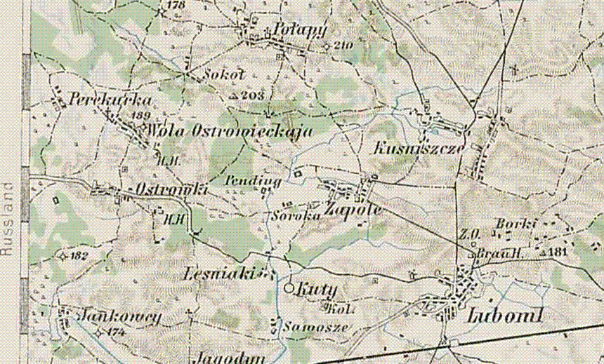
English: The area around Wólka Ostrowiecka on a military Austrian map
Polski: Okolice Wólki Ostrowieckiej na austrowęgierskiej mapie sztabowej |
| Date | |
| Source | 3rd Military Mapping Survey of Austria-Hungary |
| Author | ObOffiz. J. Mugerauer, Rittm. A. Wieg Ed. v. Wickenthal Feldw. H. Pulit, K, Bl, Br Lehmann |
Licensing
[edit]
|
This work is in the public domain in its country of origin and other countries and areas where the copyright term is the author's life plus 70 years or fewer. | |
| This file has been identified as being free of known restrictions under copyright law, including all related and neighboring rights. | |
File history
Click on a date/time to view the file as it appeared at that time.
| Date/Time | Thumbnail | Dimensions | User | Comment | |
|---|---|---|---|---|---|
| current | 10:01, 2 November 2009 | | 860 × 519 (157 KB) | Rembecki (talk | contribs) | {{Information |Description={{en|1=The area around Wólka Ostrowiecka on a military Austrian map}} {{pl|1=Okolice Wólki Ostrowieckiej na austrowęgierskiej mapie sztabowej}} |Source=3rd Military Mapping Survey of Austria-Hungary |Author=ObOffiz. J. Mugera |
You cannot overwrite this file.
File usage on Commons
There are no pages that use this file.
File usage on other wikis
The following other wikis use this file:
- Usage on pl.wikipedia.org
- Usage on uk.wikipedia.org
- Usage on zh.wikipedia.org