File:Wimbledon Station geograph-2557838-by-Ben-Brooksbank.jpg
Jump to navigation
Jump to search

Size of this preview: 800 × 493 pixels. Other resolutions: 320 × 197 pixels | 640 × 395 pixels | 1,024 × 632 pixels | 1,280 × 790 pixels | 1,772 × 1,093 pixels.
Original file (1,772 × 1,093 pixels, file size: 489 KB, MIME type: image/jpeg)
Captions
Captions
Add a one-line explanation of what this file represents
| Description |
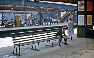
English: On the platforms at Wimbledon Station. View souhward from Platforms 5/6 to Platforms 7/8 and 9/10 as they were in 1966: BR(SR) main line and suburban lines from Waterloo (left) to Woking etc. and Epsom etc. (right). I am standing on the platforms serving the Up Fast and Slow lines, looking across to the corresponding Down platforms, beyond which are those serving the Holborn Viaduct - Sutton service and the shuttle to West Croydon (now Croydon Tramlink). Note how smart everyone is! - also the poster for the Biggin Hill Air Show. |
||
| Date | Taken on 30 April 1966 | ||
| Source | From geograph.org.uk | ||
| Author | Ben Brooksbank | ||
| Permission (Reusing this file) |
This file is licensed under the Creative Commons Attribution-Share Alike 2.0 Generic license. Attribution: Ben Brooksbank
|
||
| Attribution (required by the license) | Ben Brooksbank / On the platforms at Wimbledon Station / | ||

| Camera location | | View this and other nearby images on: OpenStreetMap |
|---|
File history
Click on a date/time to view the file as it appeared at that time.
| Date/Time | Thumbnail | Dimensions | User | Comment | |
|---|---|---|---|---|---|
| current | 14:35, 6 September 2011 | | 1,772 × 1,093 (489 KB) | Chevin (talk | contribs) | == {{int:filedesc}} == {{Information |Description={{en|1=On the platforms at Wimbledon Station View souhward from Platforms 5/6 to Platforms 7/8 and 9/10 as they were in 1966: BR(SR) main line and suburban lines from Waterloo (left) to Woking etc. and Eps |
You cannot overwrite this file.
File usage on Commons
There are no pages that use this file.
File usage on other wikis
The following other wikis use this file:
- Usage on it.wikipedia.org