File:Wien - russisch-orthodoxe Kathedrale.JPG
Jump to navigation
Jump to search

Size of this preview: 400 × 600 pixels. Other resolutions: 160 × 240 pixels | 320 × 480 pixels | 512 × 768 pixels | 682 × 1,024 pixels | 1,365 × 2,048 pixels | 2,834 × 4,251 pixels.
Original file (2,834 × 4,251 pixels, file size: 9.52 MB, MIME type: image/jpeg)
Captions
Captions
Add a one-line explanation of what this file represents
Summary
[edit]
| Description |
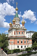
Deutsch: Die russisch-orthodoxe Kathedrale hl. Nikolaus an der Adresse Jaurèsgasse 2 im 3. Wiener Gemeindebezirk Landstraße.
Die Kathedrale wurde von 1893 bis 1899 als zweigeschossiger freistehender späthistoristischer Backsteinbau in russisch-spätbyzantinischem Stil nach Plänen des St. Petersburger Architekten Grigorij Iwanowitsch Kotov vom italienischen Architekten Luigi Ritter von Giacomelli als Botschaftskirche errichtet. |
| Date | |
| Source | Own work |
| Author | C.Stadler/Bwag |
| Permission (Reusing this file) |
Deutsch: Hallo, du darfst meine Fotos kostenlos nutzen, aber nenne mich bitte als Fotograf, beispielsweise „Foto: C.Stadler/Bwag“ oder © C.Stadler/Bwag; CC-BY-SA-4.0. Auf mehr Angaben bestehe ich nicht - im Gegensatz zu manch anderen, die die Vorgaben der unten angeführten Lizenzierung auf Punkt und Beistrich einfordern. English: Feel free to use my photos, but please mention me as the author like © C.Stadler/Bwag or © C.Stadler/Bwag; CC-BY-SA-4.0 (that's good enough) and if you want send me a message: bwag@gmx.net. |
| Object location | | View this and other nearby images on: OpenStreetMap |
|---|
| Camera location | | View this and other nearby images on: OpenStreetMap |
|---|
Licensing
[edit]
I, the copyright holder of this work, hereby publish it under the following license:
This file is licensed under the Creative Commons Attribution-Share Alike 4.0 International license.
- You are free:
- to share – to copy, distribute and transmit the work
- to remix – to adapt the work
- Under the following conditions:
- attribution – You must give appropriate credit, provide a link to the license, and indicate if changes were made. You may do so in any reasonable manner, but not in any way that suggests the licensor endorses you or your use.
- share alike – If you remix, transform, or build upon the material, you must distribute your contributions under the same or compatible license as the original.

|
Diese Datei wurde im Rahmen von WikiDaheim 2018 in Österreich erstellt und hochgeladen. Sie wurde dem Themenbereich Denkmalschutz zugeordnet. |
File history
Click on a date/time to view the file as it appeared at that time.
| Date/Time | Thumbnail | Dimensions | User | Comment | |
|---|---|---|---|---|---|
| current | 19:34, 1 July 2018 | | 2,834 × 4,251 (9.52 MB) | Bwag (talk | contribs) | {{Information |Description= {{de|1= Innenansicht der russisch-orthodoxe Kathedrale an der Adresse Jaurèsgasse 2 im 3. Wiener Gemeindebezirk Landstraße.<br/>Die Kathedrale wurde von 1893 bis 1899 als zweigeschossiger freistehender späthistoristischer Backsteinbau in russisch-spätbyzantinischem Stil nach Plänen des St. Petersburger Architekten Grigorij Iwanowitsch Kotov vom italienischen Architekten Luigi Ritt... |
You cannot overwrite this file.
File usage on Commons
The following 7 pages use this file:
- User:Paris 16/Recent uploads/2018 July 1-2
- Commons:Files used on Wikimedia Österreich Mitglieder/2
- Category:Churches in Vienna and Austrian Eparchy
- Category:Eastern Orthodoxy in Austria
- Category:Interior of Saint Nicholas Cathedral, Vienna
- Category:Saint Nicholas Cathedral, Vienna
- Category:Vienna and Austrian Eparchy
File usage on other wikis
The following other wikis use this file:
- Usage on cs.wikipedia.org
- Usage on de.wikipedia.org
- Landstraße (Wien)
- Herz-Jesu-Kirche (Wien-Landstraße)
- Palais Harrach (Ungargasse)
- Evangelische Pauluskirche (Wien)
- Rochuskirche (Wien)
- Dome, Münster und Kathedralen in deutschsprachigen Ländern
- Russisch-orthodoxe Kathedrale (Wien)
- Mautner Markhof’sches Kinderspital
- Kathedrale Hl. Sava (Wien)
- Christ Church Vienna
- Muttergotteskirche (Landstraße)
- Pfarrkirche St. Othmar unter den Weißgerbern
- Vereinssynagoge Untere Viaduktgasse
- Armenische Kirche Wien
- Elisabethinenkirche (Wien)
- Vorlage:Navigationsleiste Sakralbauten in der Landstraße
- Pfarrkirche Erdberg (Wien)
- Pfarrkirche Rennweg
- Arsenalkirche
- Evangelische Koreanische Kirche (Wien)
- Pfarrkirche Neuerdberg
- Salesianerinnenkirche (Wien)
- Gardekirche
- Eparchie für Wien und Österreich
- Nikolaikirche (Wien)
- Erlöserkirche (Landstraße)
- Sacré-Cœur-Klosterkirche (Wien)
- Wikipedia:WikiDaheim/Vorjury 2018
- Wikipedia:WikiProjekt Österreich/WD/Landstraße
- Wikipedia:WikiDaheim/Archiv 2018
- Wikipedia:WikiProjekt Österreich/checks/Denkmalschutz/WP - WD diffs 08
- Usage on en.wikipedia.org
- Usage on fr.wikipedia.org
- Usage on hu.wikipedia.org
- Usage on pl.wikipedia.org
- Usage on ru.wikipedia.org
- Usage on uk.wikipedia.org
- Usage on www.wikidata.org