File:Western Sewage Pumping Station, Grosvenor Road - geograph.org.uk - 1162540.jpg
Western_Sewage_Pumping_Station,_Grosvenor_Road_-_geograph.org.uk_-_1162540.jpg (640 × 429 pixels, file size: 122 KB, MIME type: image/jpeg)
Captions
Captions
Summary
[edit]
| Description |
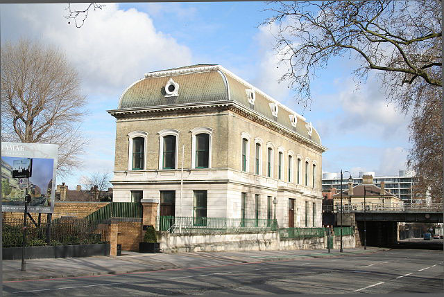
English: Western Sewage Pumping Station, Grosvenor Road. From: 'Pimlico', Old and New London: Volume 5 (1878), pp. 39-49. URL: http://www.british-history.ac.uk/report.aspx?compid=45221
"One of the principal buildings erected upon it is the Western Pumping Station, which was finished in 1874-5, completing the maindrainage system of the metropolis. The foundation-stone of the structure was laid in 1873, and the works cost about £183,000. This station provides pumping power to lift the sewage and a part of the rainfall contributed by the district, together estimated at 38,000 gallons per minute, a height of eighteen feet in the Low Level Sewer, which extends from Pimlico to the Abbey Mills Pumping Station, near Barking, in Essex. The requisite power is obtained from four high-pressure condensing beam-engines of an aggregate of 360-horse power. Supplementary power, to be used in case of accident to the principal engines, or on any similar emergency, is provided by an additional high-pressure, non-condensing engine of 120-horse power, supplied from two boilers similar to those for the principal engines. This engine and its boilers are erected in a separate building to the rear of the main buildings, near the canal. The works further comprise coal vaults, settling pond, and reservoirs for condensing water, repairing-shops, stores, and dwelling-houses for the workmen and superintendent in charge of the works. In all they cover nearly four acres. The principal enginehouse is situate facing the main road and river, and the height of this building rises to upwards of seventy-one feet." Since Chris Allen's 1991 picture, 611720, the building has been cleaned up - and the lighting column removed. |
| Date | |
| Source | From geograph.org.uk |
| Author | Alan Murray-Rust |
| Attribution (required by the license) | Alan Murray-Rust / Western Sewage Pumping Station, Grosvenor Road / |
| Camera location | | View this and other nearby images on: OpenStreetMap |
|---|
_heading:67.00&language=en)
| Object location | | View this and other nearby images on: OpenStreetMap |
|---|
_heading:67.00&language=en)
Licensing
[edit]

|
This image was taken from the Geograph project collection. See this photograph's page on the Geograph website for the photographer's contact details. The copyright on this image is owned by Alan Murray-Rust and is licensed for reuse under the Creative Commons Attribution-ShareAlike 2.0 license.
|
- You are free:
- to share – to copy, distribute and transmit the work
- to remix – to adapt the work
- Under the following conditions:
- attribution – You must give appropriate credit, provide a link to the license, and indicate if changes were made. You may do so in any reasonable manner, but not in any way that suggests the licensor endorses you or your use.
- share alike – If you remix, transform, or build upon the material, you must distribute your contributions under the same or compatible license as the original.
File history
Click on a date/time to view the file as it appeared at that time.
| Date/Time | Thumbnail | Dimensions | User | Comment | |
|---|---|---|---|---|---|
| current | 15:37, 25 February 2011 | | 640 × 429 (122 KB) | GeographBot (talk | contribs) | == {{int:filedesc}} == {{Information |description={{en|1=Western Sewage Pumping Station, Grosvenor Road From: 'Pimlico', Old and New London: Volume 5 (1878), pp. 39-49. URL: http://www.british-history.ac.uk/report.aspx?compid=45221 "One of the principal |
You cannot overwrite this file.
File usage on Commons
There are no pages that use this file.
File usage on other wikis
The following other wikis use this file:
- Usage on de.wikipedia.org