File:Volyn regions.svg
Jump to navigation
Jump to search

Size of this PNG preview of this SVG file: 546 × 599 pixels. Other resolutions: 219 × 240 pixels | 437 × 480 pixels | 700 × 768 pixels | 933 × 1,024 pixels | 1,866 × 2,048 pixels | 718 × 788 pixels.
Original file (SVG file, nominally 718 × 788 pixels, file size: 532 KB)
Captions
Captions
Add a one-line explanation of what this file represents
Summary
[edit]
| Description |
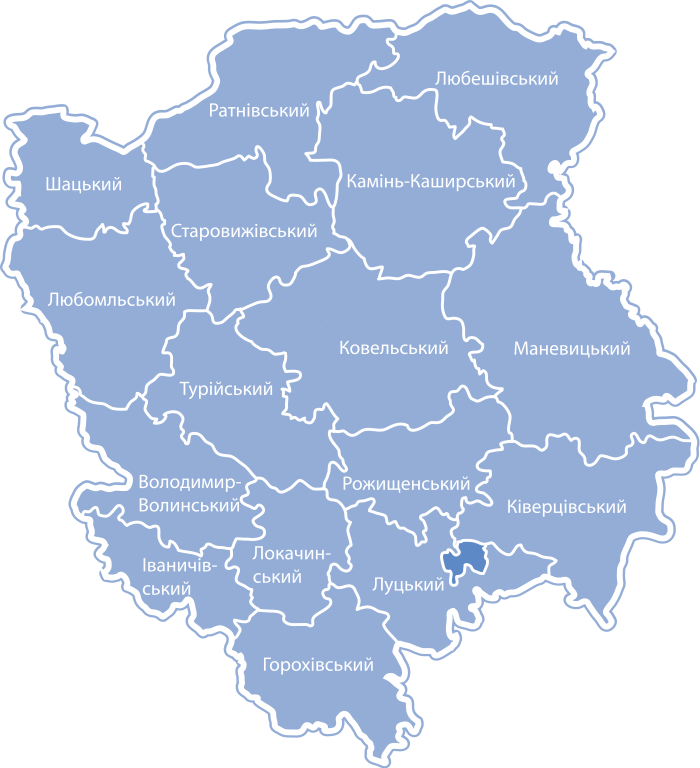
English: Districts of Vinnytsia Oblast Українська: Карта-схема районів Вінницької області |
| Date | 20 January 2009 (original upload date) |
| Source | Transferred from uk.wikipedia to Commons. |
| Author | Катерина Ткачова (uk:Користувач:Kaha); original uploader was VictorAnyakin at Ukrainian Wikipedia; modified by DenysZ |
| Permission (Reusing this file) |
Licensing
[edit]
This file is licensed under the Creative Commons Attribution-Share Alike 3.0 Unported license.
- You are free:
- to share – to copy, distribute and transmit the work
- to remix – to adapt the work
- Under the following conditions:
- attribution – You must give appropriate credit, provide a link to the license, and indicate if changes were made. You may do so in any reasonable manner, but not in any way that suggests the licensor endorses you or your use.
- share alike – If you remix, transform, or build upon the material, you must distribute your contributions under the same or compatible license as the original.
Original upload log
[edit]
The original description page was here. All following user names refer to uk.wikipedia.
- 2009-01-20 11:19 VictorAnyakin 833×870× (788806 bytes) {{Зображення |Назва=Vinnycya_regions.svg |Опис=Карта-схема районів Волинської області |Автор=Катерина Ткачова ([[Користувач:Kaha]]) |Джерело=власна робот�
File history
Click on a date/time to view the file as it appeared at that time.
| Date/Time | Thumbnail | Dimensions | User | Comment | |
|---|---|---|---|---|---|
| current | 09:09, 6 September 2014 | | 718 × 788 (532 KB) | Ymblanter (talk | contribs) | {{Information |Description ={{en|1=to bypass the bloody form as well}} |Source =uk.wikipedia |Author =to bypass this bloody form |Date = |Permission = |other_versions = }} Category:Volyn Oblast |
You cannot overwrite this file.
File usage on Commons
There are no pages that use this file.
File usage on other wikis
The following other wikis use this file:
- Usage on ba.wikipedia.org
- Usage on bg.wikipedia.org
- Usage on en.wikipedia.org
- Usage on ru.wikipedia.org
- Usage on uk.wikipedia.org