File:Vojvodina politics map.png
Jump to navigation
Jump to search

Size of this preview: 380 × 600 pixels. Other resolutions: 152 × 240 pixels | 304 × 480 pixels | 760 × 1,200 pixels.
Original file (760 × 1,200 pixels, file size: 204 KB, MIME type: image/png)
Captions
Captions
Add a one-line explanation of what this file represents
Summary
[edit]
| Description |
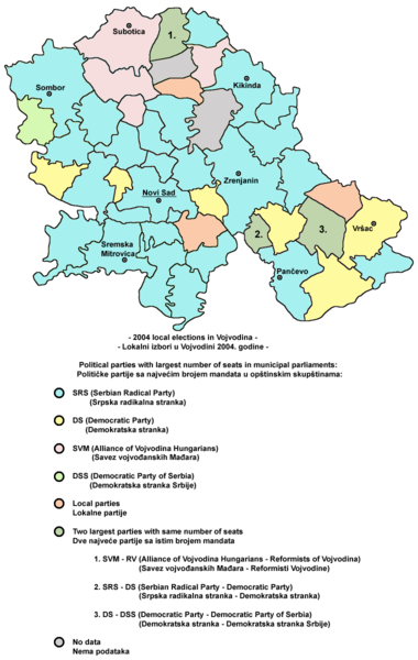
English: Election map of Vojvodina from 2004 - results of local elections.
Српски / srpski: Izborna mapa Vojvodine iz 2004. godine - rezultati lokalnih izbora. |
| Date | 9 February 2009 (original upload date) |
| Source | No machine-readable source provided. Own work assumed (based on copyright claims). |
| Author | No machine-readable author provided. PANONIAN assumed (based on copyright claims). |
Source
[edit]
self made work
Map was originally uploaded in English Wikipedia: http://en.wikipedia.org/wiki/File:Vojvodina_politics.png
It was modified version of another map originally created by user:PANONIAN. Map was modified by user:Livada and modified again by user:PANONIAN.
Licensing
[edit]
| I, the copyright holder of this work, release this work into the public domain. This applies worldwide. In some countries this may not be legally possible; if so: I grant anyone the right to use this work for any purpose, without any conditions, unless such conditions are required by law. |
References
[edit]
Made according to the data from http://www.cesid.org/
File history
Click on a date/time to view the file as it appeared at that time.
| Date/Time | Thumbnail | Dimensions | User | Comment | |
|---|---|---|---|---|---|
| current | 21:37, 10 April 2010 | | 760 × 1,200 (204 KB) | WikiEditor2004 (talk | contribs) | improved version - better aesthetics |
| 20:19, 12 February 2009 |  | 772 × 1,056 (81 KB) | WikiEditor2004 (talk | contribs) | ||
| 17:16, 12 February 2009 |  | 772 × 1,056 (74 KB) | WikiEditor2004 (talk | contribs) | ||
| 22:54, 9 February 2009 |  | 766 × 793 (53 KB) | WikiEditor2004 (talk | contribs) | election map of Vojvodina from 2004 (self made) {{PD-self}} Category:Maps of Vojvodina Category:Election maps of Serbia |
You cannot overwrite this file.
File usage on Commons
The following page uses this file:
File usage on other wikis
The following other wikis use this file:
- Usage on br.wikipedia.org
- Usage on en.wikipedia.org
- Usage on fr.wikipedia.org
- Usage on hr.wikipedia.org
- Usage on hu.wikipedia.org
- Usage on it.wikipedia.org
- Usage on ru.wikipedia.org
- Usage on sh.wikipedia.org
- Usage on sr.wikipedia.org