File:Vojvodina okruzi regioni sr.png
From Wikimedia Commons, the free media repository
Jump to navigation
Jump to search

Size of this preview: 589 × 600 pixels. Other resolutions: 236 × 240 pixels | 471 × 480 pixels | 972 × 990 pixels.
Original file (972 × 990 pixels, file size: 69 KB, MIME type: image/png)
File information
Structured data
Captions
Captions
Add a one-line explanation of what this file represents
| DescriptionVojvodina okruzi regioni sr.png |
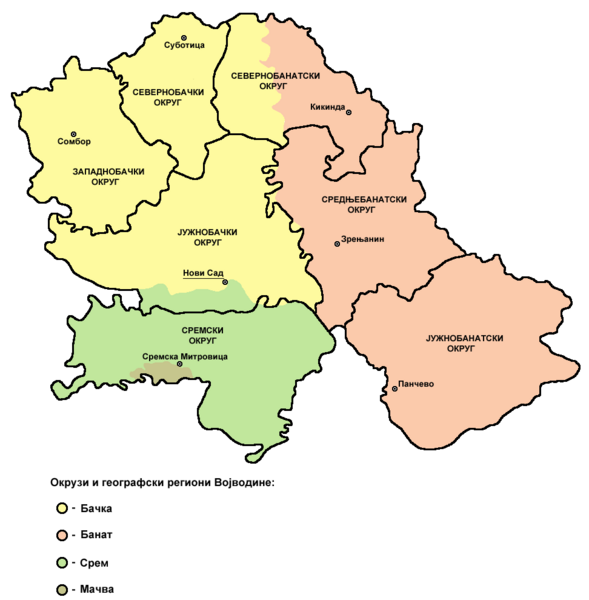
English: map of districts and geographical regions in Vojvodina - Serbian language version. Serbian: мапа округа и географских региона у Војводини - верзија на српском језику. Source and licenceself made map by user:PANONIAN References
|
|||
| Source | Own work | |||
| Author | PANONIAN | |||
| Permission (Reusing this file) |
|
File history
Click on a date/time to view the file as it appeared at that time.
| Date/Time | Thumbnail | Dimensions | User | Comment | |
|---|---|---|---|---|---|
| current | 19:44, 22 November 2011 |  | 972 × 990 (69 KB) | WikiEditor2004 (talk | contribs) | aesthetics |
| 21:55, 25 September 2009 |  | 972 × 990 (69 KB) | WikiEditor2004 (talk | contribs) | {{Information |Description={{en|1===Description== *'''English:''' map of districts and geographical regions in Vojvodina - Serbian language version. *'''Serbian:''' мапа округа и географских региона у Војводини - в� |
You cannot overwrite this file.
File usage on Commons
There are no pages that use this file.