File:US flood map 2008-06-10.jpg
From Wikimedia Commons, the free media repository
Jump to navigation
Jump to search
US_flood_map_2008-06-10.jpg (529 × 364 pixels, file size: 65 KB, MIME type: image/jpeg)
File information
Structured data
Captions
Captions
Add a one-line explanation of what this file represents
| DescriptionUS flood map 2008-06-10.jpg |
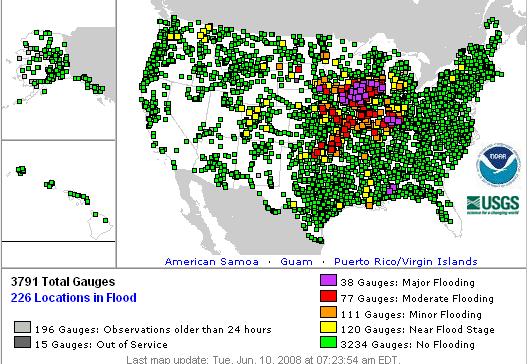
English: Map of River Flooding as of June 10th, 2008 after floods hit Midwest from the USGS. |
||||
| Date | |||||
| Source | http://www.weather.gov/ahps/index.php | ||||
| Author | National Weather Service | ||||
| Permission (Reusing this file) |
|
 | This image was uploaded in the JPEG format even though it consists of non-photographic data. This information could be stored more efficiently or accurately in the PNG or SVG format. If possible, please upload a PNG or SVG version of this image without compression artifacts, derived from a non-JPEG source (or with existing artifacts removed). After doing so, please tag the JPEG version with {{Superseded|NewImage.ext}} and remove this tag. This tag should not be applied to photographs or scans. If this image is a diagram or other image suitable for vectorisation, please tag this image with {{Convert to SVG}} instead of {{BadJPEG}}. If not suitable for vectorisation, use {{Convert to PNG}}. For more information, see {{BadJPEG}}. |
File history
Click on a date/time to view the file as it appeared at that time.
| Date/Time | Thumbnail | Dimensions | User | Comment | |
|---|---|---|---|---|---|
| current | 15:56, 10 July 2008 |  | 529 × 364 (65 KB) | Dha (talk | contribs) | {{Information |Description={{en|Map of River Flooding as of June 10th, 2008 after floods hit Midwest from the USGS. == Licensing: == ==Source== http://www.weather.gov/ahps/index.php}} |Source=Transferred from [http://en.wikipedia.org en.wikipedia]; tran |
You cannot overwrite this file.
File usage on Commons
The following page uses this file:
- File:River Flooding.JPG (file redirect)
File usage on other wikis
The following other wikis use this file:
- Usage on en.wikipedia.org


