File:USGS-Kīlauea2018-EasternRiftZoneMap.jpg
Jump to navigation
Jump to search

Size of this preview: 776 × 600 pixels. Other resolutions: 311 × 240 pixels | 621 × 480 pixels | 994 × 768 pixels | 1,280 × 989 pixels | 2,560 × 1,978 pixels | 3,300 × 2,550 pixels.
Original file (3,300 × 2,550 pixels, file size: 3.75 MB, MIME type: image/jpeg)
Captions
Captions
Add a one-line explanation of what this file represents
Summary
[edit]
| Description |
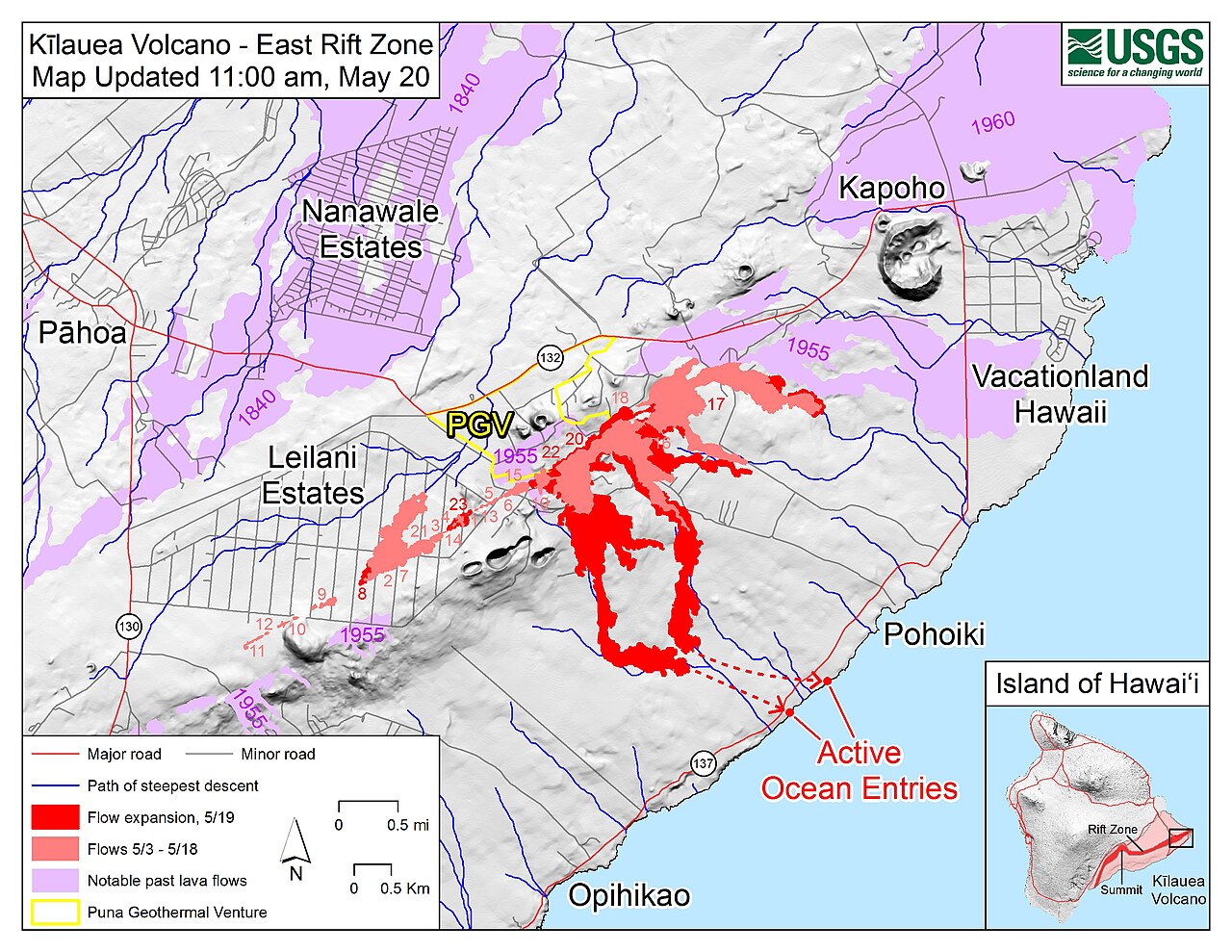
English: A map from the USGS of fissure and flow activity on the Eastern Rift Zone of Kīlauea in 2018 Obtained from Kīlauea East Rift Zone Fissure Map which may be used to provide updated versions. |
| Important update notice | This file is used in some projects to illustrate the specific situation on May 20 at 11:00 a.m. HST. Therefore please consider the respective discussion before any updating. |
| Date | |
| Source | United States Department of the Interior |
| Author | United States Geological Survey |
Licensing
[edit]
This work is in the public domain in the United States because it is a work prepared by an officer or employee of the United States Government as part of that person’s official duties under the terms of Title 17, Chapter 1, Section 105 of the US Code.
Note: This only applies to original works of the Federal Government and not to the work of any individual U.S. state, territory, commonwealth, county, municipality, or any other subdivision. This template also does not apply to postage stamp designs published by the United States Postal Service since 1978. (See § 313.6(C)(1) of Compendium of U.S. Copyright Office Practices). It also does not apply to certain US coins; see The US Mint Terms of Use.
|
 | |
| This file has been identified as being free of known restrictions under copyright law, including all related and neighboring rights. | ||
File history
Click on a date/time to view the file as it appeared at that time.
| Date/Time | Thumbnail | Dimensions | User | Comment | |
|---|---|---|---|---|---|
| current | 05:04, 21 May 2018 | | 3,300 × 2,550 (3.75 MB) | Sloyment (talk | contribs) | update |
| 15:23, 19 May 2018 |  | 3,300 × 2,550 (3.81 MB) | Skycycle (talk | contribs) | Updated version | |
| 18:28, 17 May 2018 |  | 3,300 × 2,550 (3.73 MB) | Pmaccabe (talk | contribs) | Updated map. May 16, 2018 | |
| 18:27, 17 May 2018 |  | 3,300 × 2,550 (4.07 MB) | Pmaccabe (talk | contribs) | Updated map. May 15, 2018 | |
| 18:26, 17 May 2018 |  | 908 × 702 (544 KB) | Pmaccabe (talk | contribs) | Updated map. May 14, 2018 | |
| 18:13, 14 May 2018 |  | 3,300 × 2,550 (4.16 MB) | Pmaccabe (talk | contribs) | Updated map. May 13, 2018 | |
| 18:20, 13 May 2018 |  | 3,300 × 2,550 (4.15 MB) | Pmaccabe (talk | contribs) | May 12, 2018 Updated map | |
| 19:41, 10 May 2018 |  | 3,300 × 2,550 (3.23 MB) | Pmaccabe (talk | contribs) | User created page with UploadWizard |
You cannot overwrite this file.
File usage on Commons
The following 7 pages use this file:
- User:Holly Cheng/Recent uploads/Hawaii/2018 May 10
- User:Holly Cheng/Recent uploads/Hawaii/2018 May 13
- User:Holly Cheng/Recent uploads/Hawaii/2018 May 14
- User:Holly Cheng/Recent uploads/Hawaii/2018 May 17
- User:Holly Cheng/Recent uploads/Hawaii/2018 May 19
- User:Holly Cheng/Recent uploads/Hawaii/2018 May 21
- File:USGS Kīlauea image-436.jpg (file redirect)
File usage on other wikis
The following other wikis use this file:
- Usage on ba.wikipedia.org
- Usage on ca.wikipedia.org
- Usage on de.wikipedia.org
- Usage on ru.wikipedia.org
Categories:
- Volcanic damage at Kīlauea
- Maps of Kilauea 2018 eruptions
- May 2018 in Hawaii
- Leilani Estates, Hawaii
- Active lava flows in Hawaii
- Lava flows covering roads in Hawaii
- Maps of Hawaii County, Hawaii
- Puna district, Hawaii
- Malama Flats
- Hawaii Route 137
- Lava ocean entry at Kīlauea in 2018
- Kilauea 2018 eruptions (May 9)
- Kīlauea's 2018 lower Puna eruption