File:Turkmenistan BV042517228.jpg
Jump to navigation
Jump to search

Size of this preview: 800 × 573 pixels. Other resolutions: 320 × 229 pixels | 640 × 459 pixels | 1,024 × 734 pixels | 1,280 × 917 pixels | 2,560 × 1,834 pixels | 3,456 × 2,476 pixels.
Original file (3,456 × 2,476 pixels, file size: 797 KB, MIME type: image/jpeg)
Captions
Captions
Add a one-line explanation of what this file represents
Summary
[edit]| Title |
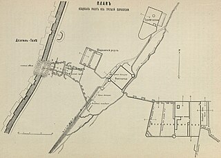
Plan osadnych rabot iz tret'ej paralleli |
|||||||||||||||||||||||
| Description |
Deutsch: Turkmenistan, Gökdepe |
|||||||||||||||||||||||
| Date | ||||||||||||||||||||||||
| Source | Leibniz-Institut für Ost- und Südosteuropaforschung (IOS) GeoPortOst | |||||||||||||||||||||||
| Permission (Reusing this file) |
|
|||||||||||||||||||||||
| Geotemporal data | ||||||||||||||||||||||||
| Date depicted | ||||||||||||||||||||||||
| Map location | Turkmenistan | |||||||||||||||||||||||
| Map type | Geschichtskarte | |||||||||||||||||||||||
| Bounding box |
|
|||||||||||||||||||||||
| Georeferencing | ||||||||||||||||||||||||
| Bibliographic data | ||||||||||||||||||||||||
| Map sheet | S. 151 | |||||||||||||||||||||||
| Language | Russian | |||||||||||||||||||||||
| Archival data | ||||||||||||||||||||||||
| Collection |
|
|||||||||||||||||||||||
| Accession number |
BV042517228 |
|||||||||||||||||||||||

Licensing
[edit]
|
This work is in the public domain in its country of origin and other countries and areas where the copyright term is the author's life plus 70 years or fewer. | |
| This file has been identified as being free of known restrictions under copyright law, including all related and neighboring rights. | |
File history
Click on a date/time to view the file as it appeared at that time.
| Date/Time | Thumbnail | Dimensions | User | Comment | |
|---|---|---|---|---|---|
| current | 14:18, 26 November 2023 | | 3,456 × 2,476 (797 KB) | Enyavar (talk | contribs) | Cropped 29 % horizontally, 22 % vertically using CropTool with precise mode. |
| 12:46, 20 February 2019 |  | 4,834 × 3,158 (1.38 MB) | H.bauer26 (talk | contribs) | pattypan 18.02 |
You cannot overwrite this file.
File usage on Commons
The following page uses this file: