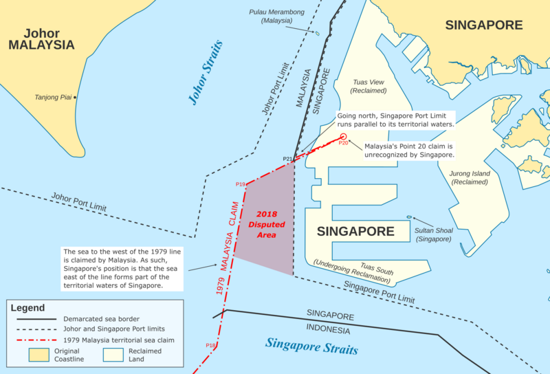
File:Tuas maritime dispute.png
From Wikimedia Commons, the free media repository
Jump to navigation
Jump to search

Size of this preview: 800 × 544 pixels. Other resolutions: 320 × 218 pixels | 640 × 435 pixels | 1,024 × 696 pixels | 1,500 × 1,020 pixels.
Original file (1,500 × 1,020 pixels, file size: 351 KB, MIME type: image/png)
File information
Structured data
Captions
Captions
Tuas maritime dispute off the coast of Johor and Singapore
Summary
[edit]| DescriptionTuas maritime dispute.png |
English: Tuas maritime dispute off the coast of Johor and Singapore |
| Date | |
| Source |
Modern layout of Malaysia and Singapore was taken from OpenStreetMap contributors Original coastline of Singapore was taken from a 1943 map digitised by the National University of Singapore and released without restrictions. Singapore port limit coordinates were obtained from the Maritime and Port Authority of Singapore Act. Red-shaded "disputed area" coordinates were obtained from the Port Marine Circulars No. 9 of 2018, which extended Singapore's port limit to the 1979 border. Johor port limit coordinates were obtained from the Marine Department Malaysia's website. Territorial sea data was obtained from Malaysia–Singapore border, Borders of Malaysia and Indonesia-Singapore border. |
| Author | Seloloving |
Licensing
[edit]This file is licensed under the Creative Commons Attribution-Share Alike 2.0 Generic license.
- You are free:
- to share – to copy, distribute and transmit the work
- to remix – to adapt the work
- Under the following conditions:
- attribution – You must give appropriate credit, provide a link to the license, and indicate if changes were made. You may do so in any reasonable manner, but not in any way that suggests the licensor endorses you or your use.
- share alike – If you remix, transform, or build upon the material, you must distribute your contributions under the same or compatible license as the original.
File history
Click on a date/time to view the file as it appeared at that time.
| Date/Time | Thumbnail | Dimensions | User | Comment | |
|---|---|---|---|---|---|
| current | 10:42, 8 June 2020 |  | 1,500 × 1,020 (351 KB) | Seloloving (talk | contribs) | removed unnecessary colours |
| 09:28, 8 June 2020 |  | 1,500 × 1,021 (349 KB) | Seloloving (talk | contribs) | more info on point 20 | |
| 23:47, 7 June 2020 |  | 1,500 × 1,021 (337 KB) | Seloloving (talk | contribs) | added more detail, larger | |
| 16:47, 7 June 2020 |  | 1,007 × 686 (182 KB) | Seloloving (talk | contribs) | Uploaded own work with UploadWizard |
You cannot overwrite this file.
File usage on Commons
There are no pages that use this file.
File usage on other wikis
The following other wikis use this file:
- Usage on en.wikipedia.org
Metadata
This file contains additional information such as Exif metadata which may have been added by the digital camera, scanner, or software program used to create or digitize it. If the file has been modified from its original state, some details such as the timestamp may not fully reflect those of the original file. The timestamp is only as accurate as the clock in the camera, and it may be completely wrong.
| Horizontal resolution | 70.93 dpc |
|---|---|
| Vertical resolution | 70.93 dpc |
| Software used |
Structured data
6 June 2020
359,666 byte
1,020 pixel
1,500 pixel
image/png
a9ba046bfb3f8b4dae58fa1dd369888670bcca60
Hidden category: