File:TroyHillInclineStation.jpg
Jump to navigation
Jump to search
No higher resolution available.
TroyHillInclineStation.jpg (600 × 407 pixels, file size: 69 KB, MIME type: image/jpeg)
Captions
Captions
Add a one-line explanation of what this file represents
Summary
[edit]
| Description |
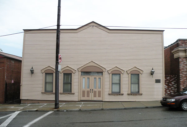
English: Picture of former upper station of the Troy Hill Incline, located at 1733 Lowrie Street in the Troy Hill neighborhood of Pittsburgh, Pennsylvania, on August 21, 2010. It is on the List of Pittsburgh History and Landmarks Foundation Historic Landmarks.
A sign on the building says the following: "Historic Site - Troy Hill Incline - This is the upper station of the first incline in Allegheny, completed in 1887 and out of service by 1898. The engineer was Samuel Diescher, a specialist in incline construction. The total length was 370 feet on a 47-percent gradient. Both freight and passengers were carried, and the incline was used especially by Pennsylvania Railroad workers who lived on Troy Hill. Pittsburgh History and Landmarks Foundation" |
| Date | |
| Source |
self-made Transferred from en.wikipedia |
| Author | Lee Paxton |
| Object location | | View this and other nearby images on: OpenStreetMap |
|---|
Licensing
[edit]
Leepaxton at en.wikipedia, the copyright holder of this work, hereby publishes it under the following licenses:

|
Permission is granted to copy, distribute and/or modify this document under the terms of the GNU Free Documentation License, Version 1.2 or any later version published by the Free Software Foundation; with no Invariant Sections, no Front-Cover Texts, and no Back-Cover Texts. A copy of the license is included in the section entitled GNU Free Documentation License. |
This file is licensed under the Creative Commons Attribution-Share Alike 4.0 International, 3.0 Unported, 2.5 Generic, 2.0 Generic and 1.0 Generic license.
Attribution: Leepaxton at en.wikipedia
- You are free:
- to share – to copy, distribute and transmit the work
- to remix – to adapt the work
- Under the following conditions:
- attribution – You must give appropriate credit, provide a link to the license, and indicate if changes were made. You may do so in any reasonable manner, but not in any way that suggests the licensor endorses you or your use.
- share alike – If you remix, transform, or build upon the material, you must distribute your contributions under the same or compatible license as the original.
You may select the license of your choice.
Original upload log
[edit]
The original description page was here. All following user names refer to en.wikipedia.
- 2010-08-27 09:45 Leepaxton 600×407 (71045 bytes) {{Information |Description=Picture of the former [[Troy Hill Incline Station]], located on Lowrie Street in the [[Troy Hill]] neighborhood of [[Pittsburgh, Pennsylvania]], on August 21, 2010. It is on the [[List of Pittsburgh History and Landmarks Founda
File history
Click on a date/time to view the file as it appeared at that time.
| Date/Time | Thumbnail | Dimensions | User | Comment | |
|---|---|---|---|---|---|
| current | 17:30, 15 October 2011 | | 600 × 407 (69 KB) | BotMultichill (talk | contribs) | {{BotMoveToCommons|en.wikipedia|year={{subst:CURRENTYEAR}}|month={{subst:CURRENTMONTHNAME}}|day={{subst:CURRENTDAY}}}} == {{int:filedesc}} == {{Information |description={{en|1=Picture of former upper station of the [[:en:Troy Hill Incline|Troy Hill Incli |
You cannot overwrite this file.
File usage on Commons
There are no pages that use this file.
File usage on other wikis
The following other wikis use this file:
- Usage on en.wikipedia.org
- Usage on eo.wikipedia.org