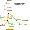
File:Tramplan gent 2011-2017.png
From Wikimedia Commons, the free media repository
Jump to navigation
Jump to search

Size of this preview: 656 × 600 pixels. Other resolutions: 263 × 240 pixels | 525 × 480 pixels | 840 × 768 pixels | 1,109 × 1,014 pixels.
Original file (1,109 × 1,014 pixels, file size: 71 KB, MIME type: image/png)
File information
Structured data
Captions
Captions
Add a one-line explanation of what this file represents
Nederlands: Lijnennet van de Gentse tram
English: Ghent tram lines
Deutsch: Liniennetz der Straßenbahn von Gent
Français : Réseau du tramway de Gand
Summary
[edit]| DescriptionTramplan gent 2011-2017.png |
Nederlands: Tijdelijk tramplan van Gent gedurende de werken op de PAG-as en de Brusselsesteenweg van september 2011 tot 2017 |
| Date | |
| Source | http://nl.wikipedia.org/wiki/Gentse_tram |
| Author | Maksim |
Licensing
[edit]This file is licensed under the Creative Commons Attribution-Share Alike 3.0 Unported license.
- You are free:
- to share – to copy, distribute and transmit the work
- to remix – to adapt the work
- Under the following conditions:
- attribution – You must give appropriate credit, provide a link to the license, and indicate if changes were made. You may do so in any reasonable manner, but not in any way that suggests the licensor endorses you or your use.
- share alike – If you remix, transform, or build upon the material, you must distribute your contributions under the same or compatible license as the original.
File history
Click on a date/time to view the file as it appeared at that time.
| Date/Time | Thumbnail | Dimensions | User | Comment | |
|---|---|---|---|---|---|
| current | 14:09, 6 June 2017 |  | 1,109 × 1,014 (71 KB) | Steven57 (talk | contribs) | Foutieve datum: ingangsdatum '21 maart 2017' moest '21 mei 2017' zijn |
| 15:24, 17 May 2017 |  | 2,218 × 2,028 (182 KB) | Steven57 (talk | contribs) | Einde van de werken aan de BraVoKo-as (Brabantdam, Vogelmarkt en Kouter). Lijn 21/22 omgevormd naar lijn 2 en als vanouds (geleden van 2012) terug over de BraVoKo-as en de PAG-as (Papegaaistraat-Rozemarijnbrug). Niet meer langs lijn 1 via de Korenmarkt... | |
| 10:40, 11 February 2016 |  | 1,956 × 1,927 (192 KB) | Steven57 (talk | contribs) | Hopelijk allerlaatste en meest correcte versie van het nieuwe Gentse tramnet (vanaf 13 maart 2016) | |
| 20:59, 10 February 2016 |  | 1,956 × 1,927 (192 KB) | Steven57 (talk | contribs) | Aanpassing lay-out "tramnet Gent vanaf 13 maart 2016". | |
| 20:55, 10 February 2016 |  | 2,002 × 1,927 (202 KB) | Steven57 (talk | contribs) | Reverted to version as of 20:39, 10 February 2016 (UTC) | |
| 20:54, 10 February 2016 |  | 2,001 × 1,926 (193 KB) | Steven57 (talk | contribs) | lay-out aanpassing van de laatste versie (tramnet vanaf 13 maart 2016) | |
| 20:39, 10 February 2016 |  | 2,002 × 1,927 (202 KB) | Steven57 (talk | contribs) | Nieuwe tramnet, geldig vanaf 13 maart 2016 (tramverlenging lijn 4 naar UZ Gent afgerond) + update deadline werken "tramverlenging lijn 21/22 naar Zwijnaarde" | |
| 11:44, 29 October 2015 |  | 961 × 987 (84 KB) | Steven57 (talk | contribs) | update van het plan - vordering werken BraVoKo (Brabantdam-Vogelmarkt-Kouter) en werken Brusselsesteenweg (werken in het smalle gedeelte) | |
| 14:33, 28 July 2014 |  | 1,922 × 1,970 (212 KB) | Steven57 (talk | contribs) | Aanpassing van het tramnet na de voltooiing van de werken aan de PAG-as en de aanvang van de werken op de BraVoKo-as | |
| 13:17, 12 April 2013 |  | 1,010 × 1,028 (74 KB) | Steven57 (talk | contribs) | Aanpassingen in planningen van verschillende projecten (verlenging lijn 21/22, verlenging lijn 4, heraanleg PAG-as en heraanleg Brusselsesteenweg) |
You cannot overwrite this file.
File usage on Commons
The following 14 pages use this file:
- User:Chumwa/OgreBot/Potential transport maps/2016 February 10-19
- User:Chumwa/OgreBot/Potential transport maps/2017 June 1-10
- User:Chumwa/OgreBot/Potential transport maps/2017 May 11-20
- User:Chumwa/OgreBot/Public transport information/2015 October 21-31
- User:Chumwa/OgreBot/Public transport information/2016 February 10-19
- User:Chumwa/OgreBot/Public transport information/2017 June 1-10
- User:Chumwa/OgreBot/Public transport information/2017 May 11-20
- User:Chumwa/OgreBot/Transport Maps/2015 October 21-31
- User:Chumwa/OgreBot/Transport Maps/2016 February 10-19
- User:Chumwa/OgreBot/Transport Maps/2017 June 1-10
- User:Chumwa/OgreBot/Transport Maps/2017 May 11-20
- User:Chumwa/OgreBot/Travel and communication maps/2016 February 10-19
- User:Chumwa/OgreBot/Travel and communication maps/2017 June 1-10
- User:Chumwa/OgreBot/Travel and communication maps/2017 May 11-20
File usage on other wikis
The following other wikis use this file:
- Usage on nl.wikipedia.org
Metadata
This file contains additional information such as Exif metadata which may have been added by the digital camera, scanner, or software program used to create or digitize it. If the file has been modified from its original state, some details such as the timestamp may not fully reflect those of the original file. The timestamp is only as accurate as the clock in the camera, and it may be completely wrong.
| Horizontal resolution | 59.05 dpc |
|---|---|
| Vertical resolution | 59.05 dpc |
Hidden category: