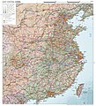
File:Topographic map of East Central China.jpg
From Wikimedia Commons, the free media repository
Jump to navigation
Jump to search

Size of this preview: 545 × 600 pixels. Other resolutions: 218 × 240 pixels | 436 × 480 pixels | 698 × 768 pixels | 931 × 1,024 pixels | 1,861 × 2,048 pixels | 2,740 × 3,015 pixels.
Original file (2,740 × 3,015 pixels, file size: 6.92 MB, MIME type: image/jpeg)
File information
Structured data
Captions
Captions
General topographic map of East Central China
Summary
[edit]| DescriptionTopographic map of East Central China.jpg |
English: General topographic map of East Central China (that is, the most populous part of the country) compiled from Natural Earth open geodata (timestamp: 2022) and stylized in European cartographic style using QGIS and Photoshop. |
| Date | |
| Source | Own work |
| Author | Janwillemvanaalst |
Licensing
[edit]I, the copyright holder of this work, hereby publish it under the following license:
This file is licensed under the Creative Commons Attribution-Share Alike 4.0 International license.
- You are free:
- to share – to copy, distribute and transmit the work
- to remix – to adapt the work
- Under the following conditions:
- attribution – You must give appropriate credit, provide a link to the license, and indicate if changes were made. You may do so in any reasonable manner, but not in any way that suggests the licensor endorses you or your use.
- share alike – If you remix, transform, or build upon the material, you must distribute your contributions under the same or compatible license as the original.
File history
Click on a date/time to view the file as it appeared at that time.
| Date/Time | Thumbnail | Dimensions | User | Comment | |
|---|---|---|---|---|---|
| current | 10:05, 28 October 2024 |  | 2,740 × 3,015 (6.92 MB) | Janwillemvanaalst (talk | contribs) | Somewhat lighter map coloring, additional new highways, a few place name corrections |
| 05:14, 14 October 2024 |  | 2,740 × 3,015 (7.11 MB) | Janwillemvanaalst (talk | contribs) | Additional corrections on city sizes and road/railway infrastructure | |
| 12:54, 6 October 2024 |  | 2,740 × 3,015 (7.11 MB) | Janwillemvanaalst (talk | contribs) | Updates on the Great Green Wall; Xi'an corrected to >10M people | |
| 11:20, 29 September 2024 |  | 2,740 × 3,015 (7.08 MB) | Janwillemvanaalst (talk | contribs) | Added mountain range names, added freight shipping lines, corrected city population sizes | |
| 06:14, 18 September 2024 |  | 2,740 × 3,015 (7.04 MB) | Janwillemvanaalst (talk | contribs) | Place label optimization, added highways and some new places | |
| 08:01, 15 September 2024 |  | 2,740 × 3,015 (7.02 MB) | Janwillemvanaalst (talk | contribs) | Added major forests; improved compressionf factor (less artefacts); corrected various city populations | |
| 05:12, 4 September 2024 |  | 2,740 × 3,015 (5.13 MB) | Janwillemvanaalst (talk | contribs) | Road infrastructure corrections, place name label optimization, added major shipping lanes and major oil/gas plants | |
| 06:06, 28 August 2024 |  | 2,740 × 3,015 (5.1 MB) | Janwillemvanaalst (talk | contribs) | Corrections on some city populations, name spelling, and highway accuracy; improved label placement | |
| 07:38, 25 August 2024 |  | 2,740 × 3,015 (5.1 MB) | Janwillemvanaalst (talk | contribs) | Corrected stylistic mistake at Beijing location | |
| 08:09, 24 August 2024 |  | 2,740 × 3,015 (5.1 MB) | Janwillemvanaalst (talk | contribs) | Updates of several outdated place names; added energy plants onshore + offshore |
You cannot overwrite this file.
File usage on Commons
There are no pages that use this file.
File usage on other wikis
The following other wikis use this file:
- Usage on en.wikipedia.org
Metadata
This file contains additional information such as Exif metadata which may have been added by the digital camera, scanner, or software program used to create or digitize it. If the file has been modified from its original state, some details such as the timestamp may not fully reflect those of the original file. The timestamp is only as accurate as the clock in the camera, and it may be completely wrong.
| Orientation | Normal |
|---|---|
| Horizontal resolution | 200 dpi |
| Vertical resolution | 200 dpi |
| Software used | Adobe Photoshop Elements 15.0 (Windows) |
| File change date and time | 10:55, 28 October 2024 |
| Color space | sRGB |
| Date and time of digitizing | 16:06, 15 August 2024 |
| Date metadata was last modified | 11:55, 28 October 2024 |
| Unique ID of original document | xmp.did:16612194-e1ca-1b49-8c3f-84d4f1c40790 |
| IIM version | 32,763 |
Hidden categories: