File:Thurston Island, Antarctica ESA386968.jpg

Original file (1,920 × 1,920 pixels, file size: 6.04 MB, MIME type: image/jpeg)
Captions
Captions
Summary
[edit]| Description |
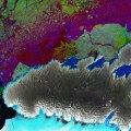
English: The Copernicus Sentinel-1 mission gives us ‘radar vision’ over part of Antarctica’s third-largest island, Thurston Island.
The satellite’s radar can ‘see’ through clouds and in the dark, making it a valuable tool for monitoring polar regions which are prone to bad weather and long periods of darkness – such as Antarctica. This image combined three passes by Sentinel-1’s radar in March, April and May 2017. Each was assigned a colour – red, green and blue – and when merged, changes between the acquisitions appear in various colours. The ice-covered island appears grey, showing no change over the three-month period. But changes in sea ice in the upper part of the image appear as speckles of green, red and blue. In the lower part of the image we can see part of the Abbot Ice Shelf appearing in light blue. Antarctica is surrounded by ice shelves, which are thick bands of ice that extend from the ice sheet and float on the coastal waters. They play an important role in buttressing the ice sheet on land, effectively slowing the sheet’s flow as it creeps seaward. The ice sheet that covers Antarctica is, by its very nature, dynamic and constantly on the move. Recently, however, there has been a worrying number of reports about its floating shelves thinning and even collapsing, allowing the grounded ice inland to flow faster to the ocean and add to sea-level rise. This image is featured on theEarth from Space video programme. |
| Date | |
| Source | http://www.esa.int/spaceinimages/Images/2017/11/Thurston_Island_Antarctica |
| Author | European Space Agency |
| Permission (Reusing this file) |
contains modified Copernicus Sentinel data (2017), processed by ESA,CC BY-SA 3.0 IGO |
| Other versions |
|
| Title | Thurston Island, Antarctica |
| Set | Earth observation image of the week |
| System | Copernicus |
| Mission | Sentinel-1 |
| Location | Antarctic |
| Activity | Observing the Earth |
| Keywords | Islands |
Licensing
[edit]
- You are free:
- to share – to copy, distribute and transmit the work
- to remix – to adapt the work
- Under the following conditions:
- attribution – You must give appropriate credit, provide a link to the license, and indicate if changes were made. You may do so in any reasonable manner, but not in any way that suggests the licensor endorses you or your use.
- share alike – If you remix, transform, or build upon the material, you must distribute your contributions under the same or compatible license as the original.

|
This image contains data from a satellite in the Copernicus Programme, such as Sentinel-1, Sentinel-2 or Sentinel-3. Attribution is required when using this image.
Attribution: Contains modified Copernicus Sentinel data {{{year}}}
The use of Copernicus Sentinel Data is regulated under EU law (Commission Delegated Regulation (EU) No 1159/2013 and Regulation (EU) No 377/2014). Relevant excerpts:
Free access shall be given to GMES dedicated data [...] made available through GMES dissemination platforms [...].
Access to GMES dedicated data [...] shall be given for the purpose of the following use in so far as it is lawful:
GMES dedicated data [...] may be used worldwide without limitations in time.
GMES dedicated data and GMES service information are provided to users without any express or implied warranty, including as regards quality and suitability for any purpose. |
File history
Click on a date/time to view the file as it appeared at that time.
| Date/Time | Thumbnail | Dimensions | User | Comment | |
|---|---|---|---|---|---|
| current | 16:59, 24 November 2017 | | 1,920 × 1,920 (6.04 MB) | Fæ (talk | contribs) | European Space Agency, Id 386968, http://www.esa.int/spaceinimages/Images/2017/11/Thurston_Island_Antarctica, User:Fæ/Project_list/ESA |
You cannot overwrite this file.
File usage on Commons
The following 3 pages use this file:
.jpg&redirect=no)