File:Tho Thomasz 1578-Haarlem.png
From Wikimedia Commons, the free media repository
Jump to navigation
Jump to search
Tho_Thomasz_1578-Haarlem.png (750 × 570 pixels, file size: 831 KB, MIME type: image/png)
File information
Structured data
Captions
Captions
Add a one-line explanation of what this file represents
Summary
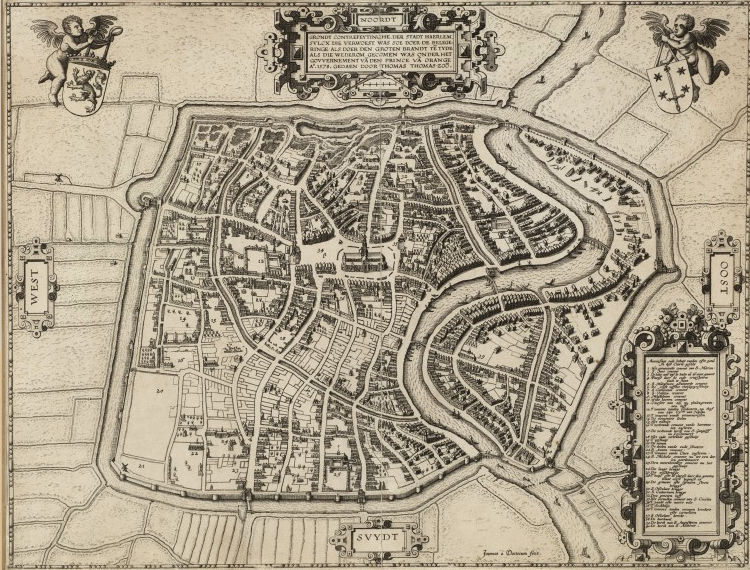
[edit]| Thomas Thomasz: English: Map of Haarlem in 1578 after the city fire that wiped out half the city buildings
( |
|||||||||||||||||||||
|---|---|---|---|---|---|---|---|---|---|---|---|---|---|---|---|---|---|---|---|---|---|
| Artist |
artist QS:P170,Q21282803 |
||||||||||||||||||||
| Title |
English: Map of Haarlem in 1578 after the city fire that wiped out half the city buildings |
||||||||||||||||||||
| Description |
Nederlands: [Kartografisch document] / door Thomas Thomaszoon; Joannes á Doetecum fecit. - Schaal [ca.1:3500]. - Haarlem : Joannes van Doetecum, [ca.1590]. - 1 kaart op papier : kopergravure ; 38,4x50,2 cm, ingelijst 65x75 cm. Naam van de kaartmaker in de titel. Naam van de graveur en uitgever rechtsonder. Afgebeeld is de plattegrond van Haarlem na het beleg door de Spanjaarden van 1572-1573 en na de grote stadsbrand van 1576. De titel is in een cartouche gevat middenboven. Links- en rechtsboven een putto met respectievelijk de wapens van Holland en Haarlem.
"NOORDT": GRONDT CONTREFEYTINGHE, DER STADT HAERLEM, SULCX DIE VERWOEST WAS SOE DOER DE BELEGERINGE ALS DOER DEN GROTEN BRANDT TE[N] TYDE ALS DIE WEDEROM GECOMEN WAS ONDER HET GOUVERNEMENT VA[N] DEN PRINCE VA[N] ORANGE Ao.1578. GEDAEN DOOR THOMAS THOMAS-ZOO[N] Aenwijzinge ende beduijt vanden cifre getal in dese caerte gestelt 1. Het geruinieerde convent van S. Marien 2. S. Jans convent 3. De halve maen tegen de breche van de viant gemaect 4. Plaetse daer de oude cruijspoorte plach te staen 5. S. Margrieten geruineerde convent 6. De croft neffens 't Heijlige geesthuijs 7. S. Catherinen convent 8. S. Ursulen convent 9. Magdalenen convent 10. Witte heren convent 11. Cloester van zijl nu phaltzgravinnen hoff 12. T'convent vanden predicaren, nu 't hof van zijn Excellentie van Nassau 13. Tçonvent vande vrouw morissen 14. De cloebeniers doelen 15. Het velhuijs 16. T'verbrande convent vande barrevoeten zusteren 17. De verbrande kerck van S. Gangolff nu d'ossenmarct 18. Het oude verbrande gasthuijs 19. T'pesthuijs 20. De ramen 21. De doelen vande oude schutters 22. S. Annen convent 23. T'convent vande Clara zusteren 24. S. Michiels convent nu tot een doelen geordenneert 25. Den minrebroeders convent nu het gasthuijs 26. De lange brugge 27. De vischbrugge 28. T'huijs ofte de plaetse daer den grooten brant eerst begonst es 29. De grauwe ofte 's graven steen brugge 30. S. Nicolaes brugge 31. S. Catherinen brugge 32. Den grooten hoff 33. Het vervallen convent van S. Cecilia 34. T'zandt ofte marct velt 35. T'clockhuijs 36. T'convent vanden vrouwen broeders ofte carmeliten 37. S. Nicolaes kercke 38. De burchwal 39. De kerck van S. Augustijnen convent 40. De kerck van S. Anthonis |
||||||||||||||||||||
| Date |
1578 date QS:P571,+1578-00-00T00:00:00Z/9 |
||||||||||||||||||||
| Medium | engraving | ||||||||||||||||||||
| Collection |
institution QS:P195,Q2200595 |
||||||||||||||||||||
| Source/Photographer | Noord-Hollands Archief | ||||||||||||||||||||
Licensing
[edit]|
This is a faithful photographic reproduction of a two-dimensional, public domain work of art. The work of art itself is in the public domain for the following reason:
The official position taken by the Wikimedia Foundation is that "faithful reproductions of two-dimensional public domain works of art are public domain".
This photographic reproduction is therefore also considered to be in the public domain in the United States. In other jurisdictions, re-use of this content may be restricted; see Reuse of PD-Art photographs for details. | |||||
| Annotations InfoField | This image is annotated: View the annotations at Commons |
643
53
57
64
750
570
English: Coat of arms of Haarlem
File history
Click on a date/time to view the file as it appeared at that time.
| Date/Time | Thumbnail | Dimensions | User | Comment | |
|---|---|---|---|---|---|
| current | 21:27, 23 February 2011 |  | 750 × 570 (831 KB) | Jane023 (talk | contribs) | {{Information |Description={{en|Map of Haarlem in 1578 after the city fire that wiped out half the city buildings; by Thomas Thomasz.}}{{nl|[Kartografisch document] / door Thomas Thomaszoon Joannes á Doetecum fecit. - Schaal [ca.1:3500]. - Haarlem : Joa |
You cannot overwrite this file.
File usage on Commons
The following 2 pages use this file:
- File:Tho Thomasz 1578-Haarlem.png
- File:Tho Thomasz 1678-Haarlem.png (file redirect)
File usage on other wikis
The following other wikis use this file:
- Usage on en.wikipedia.org
- Usage on es.wikipedia.org
- Usage on nl.wikipedia.org
- Usage on pt.wikipedia.org

