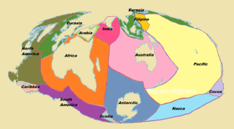
File:Tectonicplates Serret.png
Tectonicplates_Serret.png (336 × 185 pixels, file size: 40 KB, MIME type: image/png)
Captions
Captions
Summary
[edit]| DescriptionTectonicplates Serret.png |
Français : Carte des plaques tectoniques, conservant les surfaces English: Tectonic plates map, with preserved surfaces 한국어: 지각판 지도, 표면 유지 |
||
| Date | |||
| Source | Own work ; published on mappamundi.free.fr | ||
| Author | SERRET Olivier | ||
| Permission (Reusing this file) |
I, the copyright holder of this work, hereby publish it under the following licenses: This file is licensed under the Creative Commons Attribution-Share Alike 3.0 Unported license.
You may select the license of your choice. |

|
Attribution information, such as the author's name, e-mail, website, or signature, that was once visible in the image itself has been moved into the image metadata and/or image description page. This makes the image easier to reuse and more language-neutral, and makes the text easier to process and search for. Commons discourages placing visible author information in images.
Indonesia | العربيَّة | Boarisch | беларуская (тарашкевіца) | বাংলা | català | čeština | Deutsch | Ελληνικά | English | español | eesti | فارسی | suomi | français | עברית | magyar | italiano | 한국어 | македонски | മലയാളം | Plattdüütsch | Nederlands | polski | português | português do Brasil | русский | sicilianu | slovenščina | தமிழ் | Türkçe | 中文 | +/− |
File history
Click on a date/time to view the file as it appeared at that time.
| Date/Time | Thumbnail | Dimensions | User | Comment | |
|---|---|---|---|---|---|
| current | 12:29, 31 March 2012 |  | 336 × 185 (40 KB) | Centpacrr (talk | contribs) | wmr |
| 19:26, 24 February 2012 |  | 336 × 185 (39 KB) | Mapamundi~commonswiki (talk | contribs) |
You cannot overwrite this file.
File usage on Commons
There are no pages that use this file.
File usage on other wikis
The following other wikis use this file:
- Usage on an.wikipedia.org
- Usage on ar.wikipedia.org
- Usage on bat-smg.wikipedia.org
- Usage on be-tarask.wikipedia.org
- Usage on br.wikipedia.org
- Usage on bs.wikipedia.org
- Usage on ca.wikipedia.org
- Usage on ckb.wikipedia.org
- Usage on cs.wikipedia.org
- Usage on el.wikipedia.org
- Usage on en.wikipedia.org
- Usage on eo.wikipedia.org
- Usage on et.wikipedia.org
- Usage on eu.wikipedia.org
- Usage on fr.wikipedia.org
- Usage on gl.wikipedia.org
- Usage on hif.wikipedia.org
- Usage on ht.wikipedia.org
- Usage on hu.wikipedia.org
- Usage on it.wikipedia.org
- Usage on ja.wikipedia.org
- Usage on jv.wikipedia.org
- Usage on kk.wikipedia.org
- Usage on ko.wikipedia.org
- Usage on kw.wikipedia.org
- Usage on la.wikipedia.org
- Usage on li.wikipedia.org
- Usage on map-bms.wikipedia.org
- Usage on ml.wikipedia.org
- Usage on mn.wikipedia.org
- Usage on nn.wikipedia.org
- Usage on no.wikipedia.org
- Usage on oc.wikipedia.org
- Usage on om.wikipedia.org
- Usage on pnb.wikipedia.org
- Usage on ro.wikipedia.org
- Usage on ru.wikipedia.org
- Usage on sh.wikipedia.org
- Usage on simple.wikipedia.org
- Usage on sv.wikipedia.org
- Usage on sw.wikipedia.org
- Usage on ta.wikipedia.org
- Usage on th.wikipedia.org
View more global usage of this file.
Metadata
This file contains additional information such as Exif metadata which may have been added by the digital camera, scanner, or software program used to create or digitize it. If the file has been modified from its original state, some details such as the timestamp may not fully reflect those of the original file. The timestamp is only as accurate as the clock in the camera, and it may be completely wrong.
| Horizontal resolution | 37.8 dpc |
|---|---|
| Vertical resolution | 37.8 dpc |

