File:Tannenberg vertikal.jpg
Jump to navigation
Jump to search

Size of this preview: 649 × 600 pixels. Other resolutions: 260 × 240 pixels | 519 × 480 pixels | 900 × 832 pixels.
Original file (900 × 832 pixels, file size: 176 KB, MIME type: image/jpeg)
Captions
Captions
Add a one-line explanation of what this file represents
Summary
[edit]
| Description |
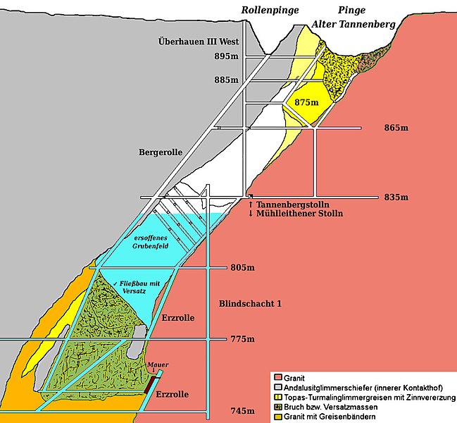
Deutsch: Vertikalschnitt durch die Lagerstätte Tannenberg |
| Date | |
| Source | Grube Tannenberg bei Tannenbergsthal, Bergarchiv Freiberg Best.-Nr. 40054 Arch.-Nr. 113 |
| Author | Mario Schmalfuß |
| Camera location | | View this and other nearby images on: OpenStreetMap |
|---|
Licensing
[edit]
This file is licensed under the Creative Commons Attribution-Share Alike 3.0 Germany license.
- You are free:
- to share – to copy, distribute and transmit the work
- to remix – to adapt the work
- Under the following conditions:
- attribution – You must give appropriate credit, provide a link to the license, and indicate if changes were made. You may do so in any reasonable manner, but not in any way that suggests the licensor endorses you or your use.
- share alike – If you remix, transform, or build upon the material, you must distribute your contributions under the same or compatible license as the original.

This file is licensed under the Creative Commons Attribution-Share Alike 3.0 Unported license.
- You are free:
- to share – to copy, distribute and transmit the work
- to remix – to adapt the work
- Under the following conditions:
- attribution – You must give appropriate credit, provide a link to the license, and indicate if changes were made. You may do so in any reasonable manner, but not in any way that suggests the licensor endorses you or your use.
- share alike – If you remix, transform, or build upon the material, you must distribute your contributions under the same or compatible license as the original.

|
Permission is granted to copy, distribute and/or modify this document under the terms of the GNU Free Documentation License, Version 1.2 or any later version published by the Free Software Foundation; with no Invariant Sections, no Front-Cover Texts, and no Back-Cover Texts. A copy of the license is included in the section entitled GNU Free Documentation License. |
Original upload log
[edit]
Transferred from de.wikipedia to Commons by Wdwdbot using script bot_filetrans.pl (r110M).
The original description page was here. All following user names refer to de.wikipedia.
- 2019-01-25 20:21:23 Kemuer (180721 Bytes) == Beschreibung, Quelle == {{Information |Beschreibung = Vertikalschnitt durch die Lagerstätte Tannenberg |Quelle = Grube Tannenberg bei Tannenbergsthal, Bergarchiv Freiberg Best.-Nr. 40054 Arch.-Nr. 113 |Urheber = eigenes Werk |Datum = 25.01.2019 |Genehmigung = |Andere Versionen = |Anmerkungen = [[Datei:NoCommons.svg|left|50px]] }}
File history
Click on a date/time to view the file as it appeared at that time.
| Date/Time | Thumbnail | Dimensions | User | Comment | |
|---|---|---|---|---|---|
| current | 17:06, 10 March 2019 | | 900 × 832 (176 KB) | Wdwdbot (talk | contribs) | Bot Move: Original uploader of this revision (#1) was Kemuer at de.wikipedia |
You cannot overwrite this file.
File usage on Commons
The following page uses this file:
File usage on other wikis
The following other wikis use this file:
- Usage on de.wikipedia.org
- Usage on www.wikidata.org