File:TabulaPeutingeriana-ZonaPompeia.jpg
TabulaPeutingeriana-ZonaPompeia.jpg (794 × 474 pixels, file size: 247 KB, MIME type: image/jpeg)
Captions
Captions
| DescriptionTabulaPeutingeriana-ZonaPompeia.jpg |
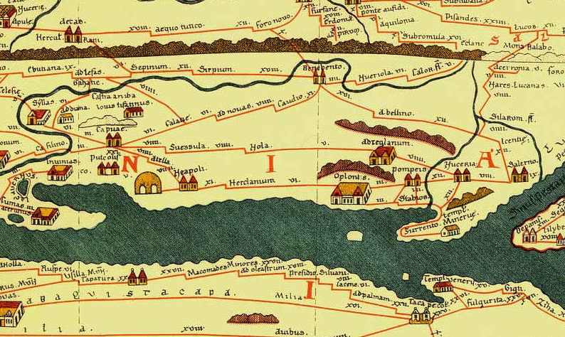
English: Crop of the Pompei's area from the Tabula Peutingeriana, 1-4th century CE. Facsimile edition by Conradi Millieri, 1887/1888
Català: Detaal de la Taula Peutingeriana a l'alçada de Pompeia-Herculà |
| Date | (UTC) |
| Source | |
| Author |
|
| This is a retouched picture, which means that it has been digitally altered from its original version. Modifications: Crop. The original can be viewed here: TabulaPeutingeriana.jpg:
|
|
This is a faithful photographic reproduction of a two-dimensional, public domain work of art. The work of art itself is in the public domain for the following reason:
The official position taken by the Wikimedia Foundation is that "faithful reproductions of two-dimensional public domain works of art are public domain".
This photographic reproduction is therefore also considered to be in the public domain in the United States. In other jurisdictions, re-use of this content may be restricted; see Reuse of PD-Art photographs for details. | |||||
Original upload log
[edit]This image is a derivative work of the following images:
- File:TabulaPeutingeriana.jpg licensed with PD-Art, PD-old
- 2007-07-10T19:12:02Z PHGCOM 21657x930 (7991717 Bytes) {{Information |Description=TabulaPeutingeriana, 1-4th century CE. Facsimile edition by Conradi Millieri, 1887/1888 |Source=[http://www.fh-augsburg.de/~harsch/Chronologia/Lspost03/Tabula/tab_pe00.html] |Date=1887 |Author=Conra
File history
Click on a date/time to view the file as it appeared at that time.
| Date/Time | Thumbnail | Dimensions | User | Comment | |
|---|---|---|---|---|---|
| current | 22:04, 18 November 2009 |  | 794 × 474 (247 KB) | Amadalvarez (talk | contribs) | {{Information |Description={{en|Crop of the Tabula Peutingeriana, 1-4th century CE. Facsimile edition by Conradi Millieri, 1887/1888}} {{fr|Détail de la Table de Peutinger.<br /> On peut y voir de gauche à droite, * en haut : |
You cannot overwrite this file.
File usage on Commons
The following 2 pages use this file:
File usage on other wikis
The following other wikis use this file:
- Usage on ca.wikipedia.org
- Usage on ceb.wikipedia.org
- Usage on de.wikivoyage.org
- Usage on el.wikipedia.org
- Usage on en.wikipedia.org
- Usage on fr.wiktionary.org
- Usage on hu.wikipedia.org
- Usage on it.wikipedia.org
- Usage on ru.wikipedia.org
- Usage on war.wikipedia.org
- Usage on www.wikidata.org
Metadata
This file contains additional information such as Exif metadata which may have been added by the digital camera, scanner, or software program used to create or digitize it. If the file has been modified from its original state, some details such as the timestamp may not fully reflect those of the original file. The timestamp is only as accurate as the clock in the camera, and it may be completely wrong.
| Orientation | Normal |
|---|---|
| Horizontal resolution | 75 dpi |
| Vertical resolution | 75 dpi |
| Software used | ACD Systems Digital Imaging |
| File change date and time | 22:09, 18 November 2009 |
| Y and C positioning | Centered |
| DateTime subseconds | 453 |
- Tabula Peutingeriana places in modern Italy
- Old maps of Campania
- Atella (ancient town)
- Atripalda
- Averno in art
- History of Benevento
- Capua in art
- Capua
- Historical images of Cumae
- Maps of Herculaneum
- Maps of Maddaloni
- Old maps of Naples
- Nola (ancient town)
- Maps of Nuceria Alfaterna
- Oplontis
- Maps of Pompeii
- Pontecagnano Faiano
- Area naturale marina protetta Punta Campanella
- Puteoli
- Old maps of Pozzuoli
- Maps of Salerno
- San Michele Arcangelo (Sant'Angelo in Formis, Capua)
- Santa Maria Capua Vetere
- Saepinum-Altilia
- Old maps of Sorrento
- Stabiae
- Suessula
- Earth sciences in the 1st century
