File:TKKP VI-2 Maryampol.jpg
Jump to navigation
Jump to search

Size of this preview: 800 × 595 pixels. Other resolutions: 320 × 238 pixels | 640 × 476 pixels | 1,024 × 761 pixels | 1,280 × 952 pixels | 2,560 × 1,903 pixels | 13,253 × 9,854 pixels.
Original file (13,253 × 9,854 pixels, file size: 41.48 MB, MIME type: image/jpeg)
Captions
Captions
Add a one-line explanation of what this file represents
| Mapa Kwatermistrzostwa, 1 : 126 000 | ||
|---|---|---|
| VI-1 (Niemen) |
VII-1 (Kowno) | |
| VI-2 (Maryampol) |
VII-2 (Preny) | |
| VI-3 (Suwałki) |
VII-3 (Sereje) | |

Summary
[edit]
| Warning | The original file is very high-resolution. It might not load properly or could cause your browser to freeze when opened at full size. |
|---|
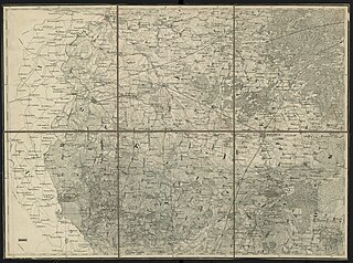
| Description | Mapa Kwatermistrzostwa, part VI-II (Maryampol) | ||||
| Date | |||||
| Source | http://igrek.amzp.pl/result.php?cmd=id&god=Kol.VI%20Sek.II&cat=TKKP126K | ||||
| Author | Kwatermistrzostwo Sztabu Generalnego Wojska Polskiego | ||||
| Permission (Reusing this file) |
|
||||
File history
Click on a date/time to view the file as it appeared at that time.
| Date/Time | Thumbnail | Dimensions | User | Comment | |
|---|---|---|---|---|---|
| current | 17:43, 15 October 2021 | | 13,253 × 9,854 (41.48 MB) | CD (talk | contribs) | == {{int:filedesc}} == {{Information |Description=Mapa Kwatermistrzostwa, part VI-II (Maryampol) |Source=http://igrek.amzp.pl/result.php?cmd=id&god=Kol.VI%20Sek.II&cat=TKKP126K |Author=Korpus Topografów w Sztabie Generalnym |Date=1843 |Permission={{PD-old}} |other_versions= }} Category:Mapa Kwatermistrzostwa |
You cannot overwrite this file.
File usage on Commons
There are no pages that use this file.
File usage on other wikis
The following other wikis use this file:
- Usage on lt.wikipedia.org
Categories:
- Mapa Kwatermistrzostwa
- Bartninkai in topographic maps
- Barzdai in topographic maps
- Daukšiai in topographic maps
- Gražiškiai in topographic maps
- Igliškėliai in topographic maps
- Jūrė in topographic maps
- Kalvarija in topographic maps
- Kazlų Rūda in topographic maps
- Keturvalakiai in topographic maps
- Kybartai in topographic maps
- Krosna in topographic maps
- Kudirkos Naumiestis in topographic maps
- Liudvinavas in topographic maps
- Marijampolė in topographic maps
- Pilviškiai in topographic maps
- Sasnava in topographic maps
- Šeštokai in topographic maps
- Šunskai in topographic maps
- Vilkaviškis in topographic maps
- Virbalis in topographic maps
- Vištytis in topographic maps
- Kazlų Rūda train station in maps
- Pilviškiai train station in maps
- Vilkaviškis train station in maps
- Virbalis train station in maps