File:Sutherland Constabulary (2301513731).jpg

Original file (998 × 1,150 pixels, file size: 196 KB, MIME type: image/jpeg)
Captions
Captions
Summary
[edit].jpg&action=edit§ion=1)
| Description |
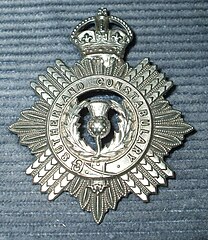
1,000 views on 10th October 2013 In common with most other police forces, Sutherland would have reviewed their badges upon the death of Queen Victoria. Police insignai had grown and developed from nothing durign her reign, and her demise after such a long period on the throne produced heraldic concern. Many forces had the Victorian crown on their helmet badges (as did Sutherland, albeit a wee one atop the wildcat rather than a huge one on top of the whole badge - see my Inverness Burgh Helmet Plate for an example). Getting new badges with the King's (a.k.a. Imperial) Crown was one option, but were helmets still essential? Many a force instead opted for a revision of headgear, either the shako (kepi/peaked pillbox) or ordinary peaked cap, sicne these were already in use by the military, and cost would be considerably less. But what to use as a cap device/badge? The Helmet plate was too large (and expensive), so the Chief Constable of Sutherland, Malcom Macdonald, would have nequired of his former force (Inverness-shire) what they were planning. The Chief of inverness-shire was of course none other than Alexander McHardy, previously Chief Constable of Sutherland, so they seem to have put their heads together and the same design was chosen by both, the only difference being the wording (County name). Doubtless it would have been economically good sense, to combine the order for Inverness-shire's 60-odd with Sutherlands' dozen. although many other County Police forces adopted the same basic design of badge, they were usually larger and in white-metal whereas those of Inverness-shire and Sutherland were otherwise unique in being small and of a brass/copper type of alloy metal. The detail is however exquisite. |
| Date | |
| Source | Sutherland Constabulary |
| Author | Dave Conner from Inverness, Scotland |
| Camera location | | View this and other nearby images on: OpenStreetMap |
|---|
.jpg¶ms=057.879765_N_-004.028173_E_globe:Earth_type:camera_source:Flickr_&language=en)
Licensing
[edit].jpg&action=edit§ion=2)
- You are free:
- to share – to copy, distribute and transmit the work
- to remix – to adapt the work
- Under the following conditions:
- attribution – You must give appropriate credit, provide a link to the license, and indicate if changes were made. You may do so in any reasonable manner, but not in any way that suggests the licensor endorses you or your use.
| This image was originally posted to Flickr by conner395 at https://flickr.com/photos/91779914@N00/2301513731. It was reviewed on 13 May 2017 by FlickreviewR and was confirmed to be licensed under the terms of the cc-by-2.0. |
File history
Click on a date/time to view the file as it appeared at that time.
| Date/Time | Thumbnail | Dimensions | User | Comment | |
|---|---|---|---|---|---|
| current | 23:31, 13 May 2017 | | 998 × 1,150 (196 KB) | Ser Amantio di Nicolao (talk | contribs) | Transferred from Flickr via Flickr2Commons |
You cannot overwrite this file.
File usage on Commons
There are no pages that use this file.
.jpg&oldid=893405925)