File:Strong-Mines-S.jpg
Jump to navigation
Jump to search
No higher resolution available.
Strong-Mines-S.jpg (539 × 380 pixels, file size: 91 KB, MIME type: image/jpeg)
Captions
Captions
Add a one-line explanation of what this file represents
Summary
[edit]
| Description |
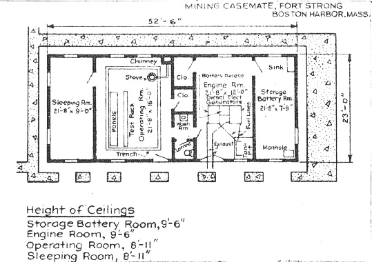
English: This plan of the mine casemate at Fort Strong, Long Island, Boston Harbor is extracted from the Reports of Completed Works (RCWs) for that fort by the U.S. Army Engineers. It dates to about 1940.
The left-hand (westerly) portion of the casemate housed the bunk room for the crew, plus the Operating Room, which contained phones, switching equipment, and power panels for the mine fields. The right-hand (easterly) portion contained generators and a room full of storage batteries. The batteries supplied the DC current that was used to test and control the mines, plus the AC current (produced by an interrupter, or a DC-AC converter) that was used to fire the mines. |
| Date | circa 1940 |
| Source | Reports of Completed Works (RCWs) |
| Author | U.S. Army Engineers |
Licensing
[edit]
This work is in the public domain in the United States because it is a work prepared by an officer or employee of the United States Government as part of that person’s official duties under the terms of Title 17, Chapter 1, Section 105 of the US Code.
Note: This only applies to original works of the Federal Government and not to the work of any individual U.S. state, territory, commonwealth, county, municipality, or any other subdivision. This template also does not apply to postage stamp designs published by the United States Postal Service since 1978. (See § 313.6(C)(1) of Compendium of U.S. Copyright Office Practices). It also does not apply to certain US coins; see The US Mint Terms of Use.
|
 | |
| This file has been identified as being free of known restrictions under copyright law, including all related and neighboring rights. | ||
File history
Click on a date/time to view the file as it appeared at that time.
| Date/Time | Thumbnail | Dimensions | User | Comment | |
|---|---|---|---|---|---|
| current | 18:34, 27 July 2010 | | 539 × 380 (91 KB) | Pgrig (talk | contribs) | This plan of the mine casemate at Fort Strong, Long Island, Boston Harbor is extracted from the Reports of Completed Works (RCWs)for that fort by the U.S. Army Engineers. It dates to about 1940. The left-hand (westerly) portion of the casemate housed the |
You cannot overwrite this file.
File usage on Commons
There are no pages that use this file.
File usage on other wikis
The following other wikis use this file:
- Usage on en.wikipedia.org