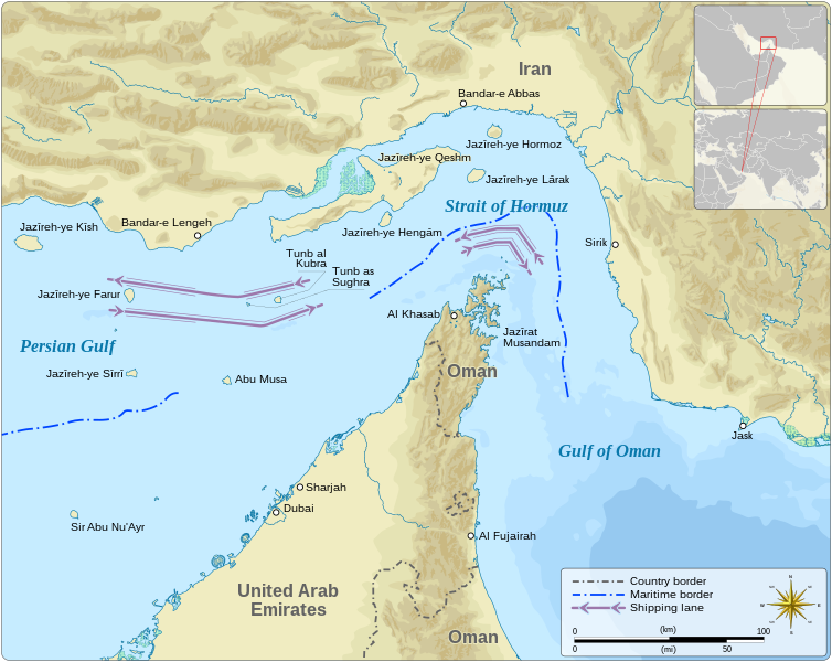
File:Strait of Hormuz-svg-en.svg

Original file (SVG file, nominally 1,264 × 1,005 pixels, file size: 2.06 MB)
Captions
Captions
Summary
[edit]| DescriptionStrait of Hormuz-svg-en.svg |
English: Map of Strait of Hormuz (English)
Dansk: Kort over Hormuzstrædet (Engelsk)
Svenska: Karta över Hormuzsundet (Engelska)
Español: Mapa del Estrecho de Ormuz (Inglés)
Русский: Карта Ормузского пролива (англ.)
فارسی: نقشهٔ تنگهٔ هرمز (انگلیسی)
institution QS:P195,Q794
institution QS:P195,Q842
institution QS:P195,Q878
institution QS:P195,Q79883 |
|||||||||||||||||||||||||||||||||||||||||||||||||||||||||||||||||||||||||||||||||||
| Date | ||||||||||||||||||||||||||||||||||||||||||||||||||||||||||||||||||||||||||||||||||||
| Source |
Own work based on: Information from: |
|||||||||||||||||||||||||||||||||||||||||||||||||||||||||||||||||||||||||||||||||||
| Author | Goran_tek-en | |||||||||||||||||||||||||||||||||||||||||||||||||||||||||||||||||||||||||||||||||||
| Permission (Reusing this file) |
This file is licensed under the Creative Commons Attribution-Share Alike 4.0 International license. Attribution: Goran_tek-en
|
|||||||||||||||||||||||||||||||||||||||||||||||||||||||||||||||||||||||||||||||||||
| Other versions |
|
|||||||||||||||||||||||||||||||||||||||||||||||||||||||||||||||||||||||||||||||||||
| SVG development InfoField | This vector image was created with Inkscape. |
|||||||||||||||||||||||||||||||||||||||||||||||||||||||||||||||||||||||||||||||||||
| Object location | 26° 36′ 00″ N, 56° 26′ 24″ E | View this and other nearby images on: OpenStreetMap |
|---|
 | Please try to get in touch with the original author Goran tek-en of this file before uploading a new version. This file is based on original data, which contains essential additional information. Therefore it is preferable to make any changes based on the original data. Thank you! Alternatively, consider uploading your new version under a new name and tagging it as a derivative or extract of this file. Deutsch ∙ English ∙ македонски ∙ português do Brasil ∙ +/− |
| This media should work for many people with some kind of color (blindness) deficiency. Due to the complexity of color deficiency, however, it may unfortunately not work for every one.
English ∙ Esperanto ∙ español ∙ Français ∙ македонски ∙ Svenska ∙ +/− |
File history
Click on a date/time to view the file as it appeared at that time.
| Date/Time | Thumbnail | Dimensions | User | Comment | |
|---|---|---|---|---|---|
| current | 14:54, 1 March 2022 |  | 1,264 × 1,005 (2.06 MB) | Goran tek-en (talk | contribs) | {{Information |description = {{en|Map of Strait of Hormuz (English)}} {{da|Kort over Hormuzstrædet (Engelsk)}} {{es|Mapa del estrecho de Ormuz (Inglés)}} {{fa|نقشهٔ تنگهٔ هرمز (انگلیسی)}} {{ru|Карта Ормузского пролива (англ.)}} {{Institution |wikidata=Q794}} {{Institution |wikidata=Q842}} {{Institution |wikidata=Q878}} {{Institution |wikidata=Q79883}} |date =2022-03-01 |source ={{Own based|Strait_of_Hormuz.jpg|Maps templ... |
You cannot overwrite this file.
File usage on Commons
The following 6 pages use this file:
File usage on other wikis
The following other wikis use this file:
- Usage on ar.wikipedia.org
- Usage on en.wikipedia.org
- Usage on he.wikipedia.org
- Usage on www.wikidata.org
Metadata
This file contains additional information such as Exif metadata which may have been added by the digital camera, scanner, or software program used to create or digitize it. If the file has been modified from its original state, some details such as the timestamp may not fully reflect those of the original file. The timestamp is only as accurate as the clock in the camera, and it may be completely wrong.
| Width | 1264.3 |
|---|---|
| Height | 1005 |


