File:Straßenbahnnetz Nürnberg.png
Jump to navigation
Jump to search

Size of this preview: 370 × 600 pixels. Other resolutions: 148 × 240 pixels | 296 × 480 pixels | 474 × 768 pixels | 631 × 1,024 pixels | 1,263 × 2,048 pixels | 4,130 × 6,696 pixels.
Original file (4,130 × 6,696 pixels, file size: 3.02 MB, MIME type: image/png)
Captions
Captions
Add a one-line explanation of what this file represents
Summary
[edit]
| Description |
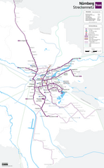
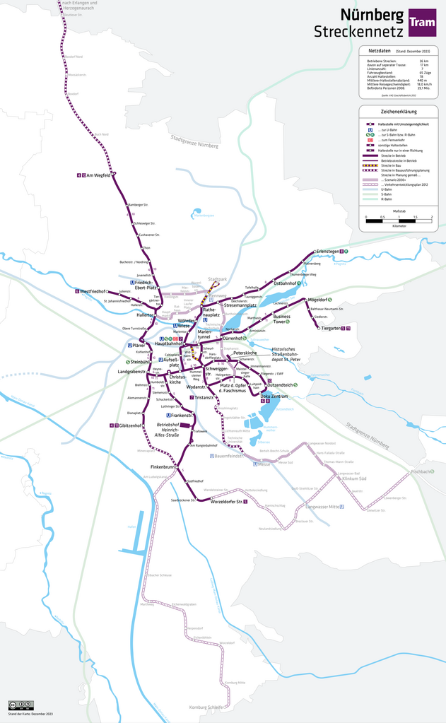
Deutsch: Karte: Netzplan der Straßenbahn Nürnberg English: Map: Nuremberg streetcar network Français : Plan: Réseau des tramways de Nuremberg |
| Date | |
| Source | Own work |
| Author | HerrMay |
Licensing
[edit]
I, the copyright holder of this work, hereby publish it under the following license:
This file is licensed under the Creative Commons Attribution-Share Alike 3.0 Unported license.
- You are free:
- to share – to copy, distribute and transmit the work
- to remix – to adapt the work
- Under the following conditions:
- attribution – You must give appropriate credit, provide a link to the license, and indicate if changes were made. You may do so in any reasonable manner, but not in any way that suggests the licensor endorses you or your use.
- share alike – If you remix, transform, or build upon the material, you must distribute your contributions under the same or compatible license as the original.
File history
Click on a date/time to view the file as it appeared at that time.
| Date/Time | Thumbnail | Dimensions | User | Comment | |
|---|---|---|---|---|---|
| current | 00:34, 21 December 2023 | | 4,130 × 6,696 (3.02 MB) | HerrMay (talk | contribs) | Größe angepasst |
| 05:39, 9 December 2023 |  | 6,883 × 11,160 (4.33 MB) | HerrMay (talk | contribs) | aktualisiert | |
| 15:48, 15 January 2021 |  | 4,130 × 6,695 (2.36 MB) | HerrMay (talk | contribs) | Haltestellen ausgebessert | |
| 15:45, 15 January 2021 |  | 5,163 × 8,370 (3.03 MB) | HerrMay (talk | contribs) | Straßenbahnplanung nach Kornburg | |
| 01:10, 25 October 2020 |  | 6,060 × 8,844 (3.27 MB) | HerrMay (talk | contribs) | Darstellung angepasst | |
| 00:22, 25 October 2020 |  | 6,062 × 8,844 (3.23 MB) | HerrMay (talk | contribs) | U3 Verlängerung | |
| 23:48, 24 October 2020 |  | 6,062 × 8,844 (3.23 MB) | HerrMay (talk | contribs) | Verlängerungen 4 und 7 | |
| 22:33, 7 January 2019 |  | 6,063 × 8,845 (3.28 MB) | HerrMay (talk | contribs) | aktualisiert und ergänzt | |
| 23:25, 19 February 2018 |  | 2,407 × 2,849 (1.12 MB) | HerrMay (talk | contribs) | Baustelle Allersberger Tunnel hinzugefügt | |
| 18:16, 10 January 2018 |  | 2,404 × 2,847 (1.33 MB) | HerrMay (talk | contribs) | Ausbesserung Haltestellennamen ''Scheurlstraße'' und ''Thumenberger Weg'' |
You cannot overwrite this file.
File usage on Commons
The following 37 pages use this file:
- Rapid transit
- Straßenbahn Nürnberg
- User:Chumwa/OgreBot/Potential transport maps/2016 December 21-31
- User:Chumwa/OgreBot/Potential transport maps/2017 December 1-10
- User:Chumwa/OgreBot/Potential transport maps/2017 June 21-30
- User:Chumwa/OgreBot/Potential transport maps/2018 February 19-28
- User:Chumwa/OgreBot/Potential transport maps/2019 January 1-10
- User:Chumwa/OgreBot/Public transport information/2016 December 21-31
- User:Chumwa/OgreBot/Public transport information/2017 December 1-10
- User:Chumwa/OgreBot/Public transport information/2017 June 21-30
- User:Chumwa/OgreBot/Public transport information/2018 February 19-28
- User:Chumwa/OgreBot/Public transport information/2019 January 1-10
- User:Chumwa/OgreBot/Public transport information/2020 October 21-31
- User:Chumwa/OgreBot/Public transport information/2021 January 11-20
- User:Chumwa/OgreBot/Public transport information/2023 December 1-10
- User:Chumwa/OgreBot/Public transport information/2023 December 21-31
- User:Chumwa/OgreBot/Transport Maps/2016 December 21-31
- User:Chumwa/OgreBot/Transport Maps/2017 December 1-10
- User:Chumwa/OgreBot/Transport Maps/2017 June 21-30
- User:Chumwa/OgreBot/Transport Maps/2018 February 19-28
- User:Chumwa/OgreBot/Transport Maps/2019 January 1-10
- User:Chumwa/OgreBot/Transport Maps/2020 October 21-31
- User:Chumwa/OgreBot/Transport Maps/2021 January 11-20
- User:Chumwa/OgreBot/Transport Maps/2023 December 1-10
- User:Chumwa/OgreBot/Transport Maps/2023 December 21-31
- User:Chumwa/OgreBot/Travel and communication maps/2016 December 21-31
- User:Chumwa/OgreBot/Travel and communication maps/2017 December 1-10
- User:Chumwa/OgreBot/Travel and communication maps/2017 June 21-30
- User:Chumwa/OgreBot/Travel and communication maps/2018 February 19-28
- User:Chumwa/OgreBot/Travel and communication maps/2019 January 1-10
- User:Clic/Nahverkehr in Deutschland/2020 October 21-31
- User:Clic/Nahverkehr in Deutschland/2021 January 11-20
- User:Clic/Nahverkehr in Deutschland/2023 December 1-10
- User:Clic/Nahverkehr in Deutschland/2023 December 21-31
- User:HerrMay
- User:Nordlicht8/Rail Germany/2013 November 21-30
- Category:Trams in Nürnberg
File usage on other wikis
The following other wikis use this file:
- Usage on de.wikipedia.org
- Usage on en.wikipedia.org
- Usage on eo.wikipedia.org
- Usage on fa.wikipedia.org
- Usage on fr.wikipedia.org
- Usage on hu.wikipedia.org
- Usage on it.wikipedia.org
- Usage on ro.wikipedia.org
- Usage on ru.wikipedia.org
- Usage on www.wikidata.org