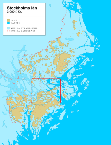
File:Stockholm county 3000-BC.png
From Wikimedia Commons, the free media repository
Jump to navigation
Jump to search

Size of this preview: 456 × 599 pixels. Other resolutions: 182 × 240 pixels | 365 × 480 pixels | 584 × 768 pixels | 779 × 1,024 pixels | 1,600 × 2,103 pixels.
Original file (1,600 × 2,103 pixels, file size: 966 KB, MIME type: image/png)
File information
Structured data
Captions
Captions
Add a one-line explanation of what this file represents
Summary
[edit]| DescriptionStockholm county 3000-BC.png |
English: The Stockholm area, around 3000 years BC (5 000 BP). The map shows post-glacial rebound and shoreline displacement in comparison with present-day Stockholm county. The extent of land at the time (yellow) was smaller than today, with water (blue tones) covering areas that are above the shoreline today. Present-day shorelines, county and municipality borders shown for comparison. Svenska: Stockholmsområdet omkring 3 000 år f. Kr (5 000 år före nutid). Landytorna (gult) var begränsade jämfört med idag. Vatten (blåa nyanser) täckte områden som idag ligger över havsytan till följd av landhöjningen. Samtida strandlinjer samt läns- och kommungränser visas för jämförelse. |
| Date | |
| Source | Own work by uploader + Online map creation; data from Stockholms länsmuseum |
| Author | Koyos |
| Other versions |
|
Licensing
[edit]| Public domainPublic domainfalsefalse |
| I, the copyright holder of this work, release this work into the public domain. This applies worldwide. In some countries this may not be legally possible; if so: I grant anyone the right to use this work for any purpose, without any conditions, unless such conditions are required by law. |
File history
Click on a date/time to view the file as it appeared at that time.
| Date/Time | Thumbnail | Dimensions | User | Comment | |
|---|---|---|---|---|---|
| current | 11:33, 5 February 2013 |  | 1,600 × 2,103 (966 KB) | Holger.Ellgaard (talk | contribs) | markerar Stockholms stads område |
| 21:17, 25 May 2009 |  | 1,600 × 2,103 (883 KB) | Koyos (talk | contribs) | {{Information |Description={{en|1=fg}} |Source=Own work by uploader |Author=Koyos |Date= |Permission= |other_versions= }} <!--{{ImageUpload|full}}--> |
You cannot overwrite this file.
File usage on Commons
The following 7 pages use this file:
File usage on other wikis
The following other wikis use this file:
- Usage on be-tarask.wikipedia.org
- Usage on be.wikipedia.org
- Usage on bs.wikipedia.org
- Usage on ca.wikipedia.org
- Usage on cv.wikipedia.org
- Usage on el.wikipedia.org
- Usage on en.wikipedia.org
- Usage on es.wikipedia.org
- Usage on fi.wikipedia.org
- Usage on frr.wikipedia.org
- Usage on fr.wikipedia.org
- Usage on fy.wikipedia.org
- Usage on hu.wikipedia.org
- Usage on kk.wikipedia.org
- Usage on koi.wikipedia.org
- Usage on kv.wikipedia.org
- Usage on la.wikipedia.org
- Usage on mk.wikipedia.org
- Usage on myv.wikipedia.org
- Usage on nn.wikipedia.org
- Usage on no.wikipedia.org
- Usage on ro.wikipedia.org
- Usage on sco.wikipedia.org
- Usage on sh.wikipedia.org
- Usage on sv.wikipedia.org
- Usage on udm.wikipedia.org
Metadata
This file contains additional information such as Exif metadata which may have been added by the digital camera, scanner, or software program used to create or digitize it. If the file has been modified from its original state, some details such as the timestamp may not fully reflect those of the original file. The timestamp is only as accurate as the clock in the camera, and it may be completely wrong.
| Copyright holder |
|
|---|---|
| Horizontal resolution | 37.8 dpc |
| Vertical resolution | 37.8 dpc |
| Software used |


