File:St.Pölten Karte Stadtteile mit Beschriftung.svg
Jump to navigation
Jump to search

Size of this PNG preview of this SVG file: 506 × 600 pixels. Other resolutions: 202 × 240 pixels | 405 × 480 pixels | 648 × 768 pixels | 864 × 1,024 pixels | 1,727 × 2,048 pixels | 1,077 × 1,277 pixels.
Original file (SVG file, nominally 1,077 × 1,277 pixels, file size: 65 KB)
Captions
Captions
Add a one-line explanation of what this file represents
| Description |
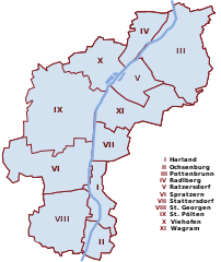
English: Map of St. Pölten
Deutsch: Karte von St. Pölten mit beschrifteten Stadtteilen. Die Zahlen sind Willkürlich nach dem Alphabet gewählt und haben keine offizielle Bedeutung |
| Date | |
| Source | Own work |
| Author | AleXXw |
| This work has been released into the public domain by its author, AleXXw. This applies worldwide. In some countries this may not be legally possible; if so: |
File history
Click on a date/time to view the file as it appeared at that time.
| Date/Time | Thumbnail | Dimensions | User | Comment | |
|---|---|---|---|---|---|
| current | 22:41, 14 January 2010 | | 1,077 × 1,277 (65 KB) | AleXXw (talk | contribs) | Pottenbrunn und Ratzersdorf vertauscht |
| 22:48, 13 April 2009 |  | 1,077 × 1,277 (88 KB) | AleXXw (talk | contribs) | Beschriftung in Legende | |
| 23:20, 25 October 2008 |  | 1,077 × 1,277 (37 KB) | AleXXw (talk | contribs) | {{Information |Description={{en|1=Map of St. Pölten, highlighting Harland}} {{de|1=Karte von St. Pölten mit dem hervorgehobenen Ortsteil Harland}} |Source=own work |Author=AleXXw |Date=2008-10-26 |Permission= |other_versions= }} {{PD-use |
You cannot overwrite this file.
File usage on Commons
The following page uses this file:
File usage on other wikis
The following other wikis use this file:
- Usage on de.wikipedia.org
- Usage on fy.wikipedia.org
- Usage on nl.wikipedia.org
- Usage on sl.wikipedia.org
- Usage on vep.wikipedia.org