File:Smith Tower (1914) - A Designated Seattle Landmark.jpg
Original file (4,608 × 2,112 pixels, file size: 2.06 MB, MIME type: image/jpeg)
Captions
Summary
[edit]DescriptionSmith Tower (1914) - A Designated Seattle Landmark.jpg |
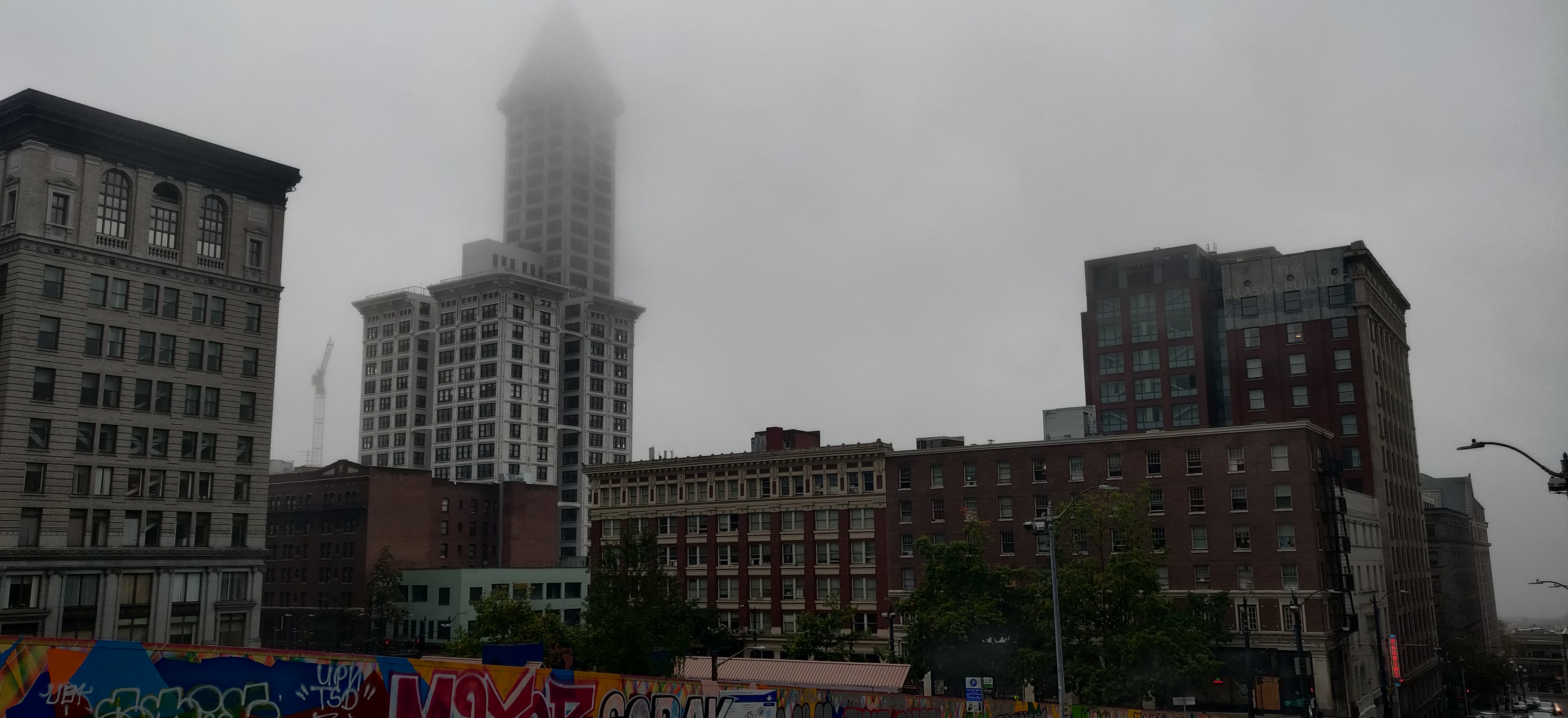
English: Once the tallest skyscraper on the West coast, Smith Tower opened in 1914 as the premiere commercial superstructure of early 20th-century architecture. For over 100 years, this iconic Seattle registered landmark housed dozens of tenants, from Microsoft and Disney to the more recent residential tenants being a wealthy family who managed to acquire the penthouse stop the tower in its recognizable pyramid-inspired loft. Tickets to visit the observation deck provides 360-degree views of the Puget Sound to the west, Mt. Rainier to the east and surrounding downtown Seattle architecture to the north and south.
|
||
Date | |||
Source | Own work | ||
Author | Brandon Elliott |
Camera location | 47° 36′ 14.5″ N, 122° 19′ 51.92″ W | View this and other nearby images on: OpenStreetMap | 47.604027; -122.331089 |
---|
Licensing
[edit]- You are free:
- to share – to copy, distribute and transmit the work
- to remix – to adapt the work
- Under the following conditions:
- attribution – You must give appropriate credit, provide a link to the license, and indicate if changes were made. You may do so in any reasonable manner, but not in any way that suggests the licensor endorses you or your use.
- share alike – If you remix, transform, or build upon the material, you must distribute your contributions under the same or compatible license as the original.
This image was uploaded as part of Wiki Loves Monuments 2020.
Afrikaans ∙ Alemannisch ∙ العربية ∙ جازايرية ∙ azərbaycanca ∙ Bikol Central ∙ беларуская ∙ беларуская (тарашкевіца) ∙ български ∙ বাংলা ∙ brezhoneg ∙ bosanski ∙ català ∙ čeština ∙ Cymraeg ∙ dansk ∙ Deutsch ∙ Zazaki ∙ Ελληνικά ∙ English ∙ Esperanto ∙ español ∙ eesti ∙ euskara ∙ فارسی ∙ suomi ∙ français ∙ Frysk ∙ Gaeilge ∙ galego ∙ עברית ∙ हिन्दी ∙ hrvatski ∙ magyar ∙ հայերեն ∙ Bahasa Indonesia ∙ Ido ∙ italiano ∙ 日本語 ∙ ქართული ∙ 한국어 ∙ кыргызча ∙ Lëtzebuergesch ∙ latviešu ∙ Malagasy ∙ македонски ∙ മലയാളം ∙ Bahasa Melayu ∙ Malti ∙ norsk bokmål ∙ नेपाली ∙ Nederlands ∙ norsk nynorsk ∙ norsk ∙ polski ∙ português ∙ português do Brasil ∙ română ∙ русский ∙ sicilianu ∙ davvisámegiella ∙ slovenčina ∙ slovenščina ∙ shqip ∙ српски / srpski ∙ svenska ∙ ไทย ∙ Tagalog ∙ Türkçe ∙ українська ∙ اردو ∙ oʻzbekcha / ўзбекча ∙ Yorùbá ∙ 中文 ∙ 中文(中国大陆) ∙ 中文(简体) ∙ 中文(繁體) ∙ 中文(香港) ∙ 中文(臺灣) ∙ +/− |
Annotations InfoField | This image is annotated: View the annotations at Commons |
King County Courthouse
Morrison Hotel
Smith Tower
Drexel Hotel
Lyon Building
St. Charles Hotel
The former Grand Opera House, now a parking garage
Alaska Building
Broderick Building (originally Bailey Building)
Lowman Building
File history
Click on a date/time to view the file as it appeared at that time.
Date/Time | Thumbnail | Dimensions | User | Comment | |
---|---|---|---|---|---|
current | 00:00, 5 October 2020 | 4,608 × 2,112 (2.06 MB) | BrandonUCD (talk | contribs) | Uploaded own work with UploadWizard |
You cannot overwrite this file.
File usage on Commons
There are no pages that use this file.
Metadata
This file contains additional information such as Exif metadata which may have been added by the digital camera, scanner, or software program used to create or digitize it. If the file has been modified from its original state, some details such as the timestamp may not fully reflect those of the original file. The timestamp is only as accurate as the clock in the camera, and it may be completely wrong.
Camera manufacturer | OnePlus |
---|---|
Camera model | ONEPLUS A6013 |
Exposure time | 1/163 sec (0.0061349693251534) |
F-number | f/1.7 |
ISO speed rating | 100 |
Date and time of data generation | 09:48, 3 October 2020 |
Lens focal length | 4.25 mm |
Latitude | 47° 36′ 14.5″ N |
Longitude | 122° 19′ 51.92″ W |
Altitude | 5.511 meters above sea level |
Width | 4,608 px |
Height | 2,112 px |
Orientation | Normal |
Horizontal resolution | 72 dpi |
Vertical resolution | 72 dpi |
File change date and time | 09:48, 3 October 2020 |
Y and C positioning | Centered |
Exposure Program | Normal program |
Exif version | 2.2 |
Date and time of digitizing | 09:48, 3 October 2020 |
Meaning of each component |
|
APEX shutter speed | 7.352 |
APEX aperture | 1.53 |
APEX brightness | 2.44 |
APEX exposure bias | 1 |
Maximum land aperture | 1.53 APEX (f/1.7) |
Metering mode | Pattern |
Light source | Unknown |
Flash | Flash did not fire, compulsory flash suppression |
DateTime subseconds | 326179 |
DateTimeOriginal subseconds | 326179 |
DateTimeDigitized subseconds | 326179 |
Supported Flashpix version | 1 |
Color space | sRGB |
Sensing method | Undefined |
Scene type | A directly photographed image |
Exposure mode | Auto exposure |
White balance | Auto white balance |
Focal length in 35 mm film | 25 mm |
Scene capture type | Standard |
GPS time (atomic clock) | 16:48 |
GPS date | 3 October 2020 |
Structured data
Items portrayed in this file
depicts
some value
3 October 2020
47°36'14.497"N, 122°19'51.920"W
0.00613496932515337423 second
1.7
4.25 millimetre
100
image/jpeg
2,158,716 byte
2,112 pixel
4,608 pixel
93816bca5a6fa5740acbf7e6a6cf62926b603a73
- National Register of Historic Places with known IDs
- National Register of Historic Places missing SDC location of creation
- Files with coordinates missing SDC location of creation
- CC-BY-SA-4.0
- Self-published work
- Images from Wiki Loves Monuments 2020
- Images from Wiki Loves Monuments 2020 in the United States
- Images from Wiki Loves Monuments 2020 in Washington
- Images from Wiki Loves Monuments missing SDC location of creation
- Images with annotations
- Images with 10+ annotations
- Wiki Loves Monuments 2020 in the United States unreviewed
- Uploaded via Campaign:wlm-us