File:Slough, Montem Mount or Mound - geograph.org.uk - 1114264.jpg
Slough,_Montem_Mount_or_Mound_-_geograph.org.uk_-_1114264.jpg (640 × 480 pixels, file size: 72 KB, MIME type: image/jpeg)
Captions
Captions
Summary
[edit]| DescriptionSlough, Montem Mount or Mound - geograph.org.uk - 1114264.jpg |
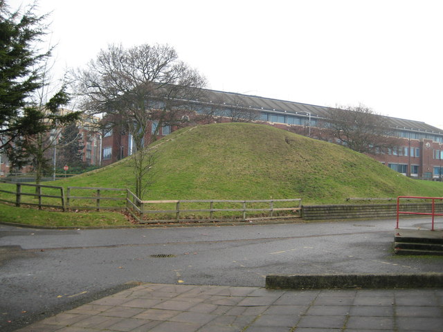
English: Slough: Montem Mount or Mound The 1881 Ordnance Survey map describes this earthwork as The Mount, a Supposed Barrow. At that time the Mount was the main feature in the hamlet of Salt Hill. The urban sprawl of Slough had yet to consume it.
However the mound's main claim to fame is that until 1844 it was the destination of the Eton Montem when every Whit Tuesday the boys of Eton College 345572 marched, army-style, to the location collecting 'salt' or money from visitors and passers-by. The ceremony dated back until at least 1561 and was regularly patronized by Royalty. In its later years it became a triennial event, with the tickets to the 1838 event costing one shilling. However in 1844 the masters of the College decided that the boys should be studying rather than indulging time in making their Montem costumes, decided that the ceremony was anachronistic and should be abandoned forthwith. In truth the real reason for its demise was that with the advent of the railways the ceremonies of 1841 and 1844 had attracted rowdy crowds brought by train from London, and the authorities feared that a serious riot could break out in a subsequent event. The Times, reporting the 1844 event tongue-in-cheek, described the crowd as "mixed"... Evidently the hoi-polloi were not to be welcomed. One wonders what would happen today if the ceremony was to be revived...! |
| Date | |
| Source | From geograph.org.uk |
| Author | Nigel Cox |
| Attribution (required by the license) InfoField | Nigel Cox / Slough: Montem Mount or Mound / |
InfoField | Nigel Cox / Slough: Montem Mount or Mound |
| Camera location | 51° 30′ 40″ N, 0° 36′ 33″ W | View this and other nearby images on: OpenStreetMap |
|---|
| Object location | 51° 30′ 40″ N, 0° 36′ 31″ W | View this and other nearby images on: OpenStreetMap |
|---|
Licensing
[edit]
|
This image was taken from the Geograph project collection. See this photograph's page on the Geograph website for the photographer's contact details. The copyright on this image is owned by Nigel Cox and is licensed for reuse under the Creative Commons Attribution-ShareAlike 2.0 license.
|
- You are free:
- to share – to copy, distribute and transmit the work
- to remix – to adapt the work
- Under the following conditions:
- attribution – You must give appropriate credit, provide a link to the license, and indicate if changes were made. You may do so in any reasonable manner, but not in any way that suggests the licensor endorses you or your use.
- share alike – If you remix, transform, or build upon the material, you must distribute your contributions under the same or compatible license as the original.
File history
Click on a date/time to view the file as it appeared at that time.
| Date/Time | Thumbnail | Dimensions | User | Comment | |
|---|---|---|---|---|---|
| current | 22:15, 24 February 2011 |  | 640 × 480 (72 KB) | GeographBot (talk | contribs) | == {{int:filedesc}} == {{Information |description={{en|1=Slough: Montem Mount or Mound The 1881 Ordnance Survey map describes this earthwork as The Mount, a Supposed Barrow. At that time the Mount was the main feature in the hamlet of Salt Hill. The urban |
You cannot overwrite this file.
File usage on Commons
There are no pages that use this file.
File usage on other wikis
The following other wikis use this file:
- Usage on de.wikipedia.org
- Usage on en.wikipedia.org
- Usage on www.wikidata.org
Metadata
This file contains additional information such as Exif metadata which may have been added by the digital camera, scanner, or software program used to create or digitize it. If the file has been modified from its original state, some details such as the timestamp may not fully reflect those of the original file. The timestamp is only as accurate as the clock in the camera, and it may be completely wrong.
| _error | 0 |
|---|
Structured data
Items portrayed in this file
depicts
51°30'40.21"N, 0°36'33.48"W
8 January 2009
51°30'40.21"N, 0°36'31.32"W
73,734 byte
480 pixel
640 pixel
image/jpeg
711d44e66032a17ff840165bd8987fc313d9de9a
- Information field template with formatting
- Files with coordinates missing SDC location of creation (51° N, 1° W)
- CC-BY-SA-2.0
- Images from Geograph Britain and Ireland
- Images from Geograph Britain and Ireland missing SDC depicts
- Images from Geograph Britain and Ireland missing SDC location of creation
- Photographs by Nigel Cox
- United Kingdom photographs taken on 2009-01-08
