File:Showa in Yamanashi Prefecture 2.png

Original file (1,001 × 801 pixels, file size: 37 KB, MIME type: image/png)
Captions
Captions
Summary
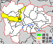
[edit]| DescriptionShowa in Yamanashi Prefecture 2.png | Location Map of Showa in Yamanashi Prefecture, Japan | ||
| Date | |||
| Source | Image:YamanashiMapCurrent.png and rework | ||
| Author | user:alberth2 | ||
| Permission (Reusing this file) |
|
||
| Other versions |
 |
Licensing
[edit]| Public domainPublic domainfalsefalse |
| I, the copyright holder of this work, release this work into the public domain. This applies worldwide. In some countries this may not be legally possible; if so: I grant anyone the right to use this work for any purpose, without any conditions, unless such conditions are required by law. |
Original upload log
[edit]
|
This file was moved from Japanese Wikipedia.
See below for original file information. | |||||||||||||||||||||||||||||||||||
| ||||||||||||||||||||||||||||||||||||
|
| ||||||||||||||||||||||||||||||||||||
File history
Click on a date/time to view the file as it appeared at that time.
| Date/Time | Thumbnail | Dimensions | User | Comment | |
|---|---|---|---|---|---|
| current | 20:13, 22 April 2021 |  | 1,001 × 801 (37 KB) | MGA73 (talk | contribs) | Reverted to version as of 01:59, 12 June 2007 (UTC) - other file is at File:Showa in Yamanashi Prefecture.png |
| 08:49, 24 October 2019 |  | 174 × 147 (3 KB) | Fgg11 (talk | contribs) | new file | |
| 01:59, 12 June 2007 |  | 1,001 × 801 (37 KB) | Alberth2 (talk | contribs) | == Summary == {{Information |Description=Location Map of Showa in Yamanashi Prefecture, Japan |Source=Image:YamanashiMapCurrent.png and rework |Date=Jun. 12th, 2007 |Author=user:alberth2 |Permission=PD |other_versions= }} == Licensing == {{PD-se |
You cannot overwrite this file.
File usage on Commons
The following page uses this file:
Metadata
This file contains additional information such as Exif metadata which may have been added by the digital camera, scanner, or software program used to create or digitize it. If the file has been modified from its original state, some details such as the timestamp may not fully reflect those of the original file. The timestamp is only as accurate as the clock in the camera, and it may be completely wrong.
| File change date and time | 01:39, 12 June 2007 |
|---|---|
| Horizontal resolution | 28 dpc |
| Vertical resolution | 28 dpc |