File:Serious accident avoided rad dose.png

Original file (969 × 450 pixels, file size: 13 KB, MIME type: image/png)
Captions
Captions
| Public domainPublic domainfalsefalse |
| This work has been released into the public domain by its author, Tungsten. This applies worldwide. In some countries this may not be legally possible; if so: |
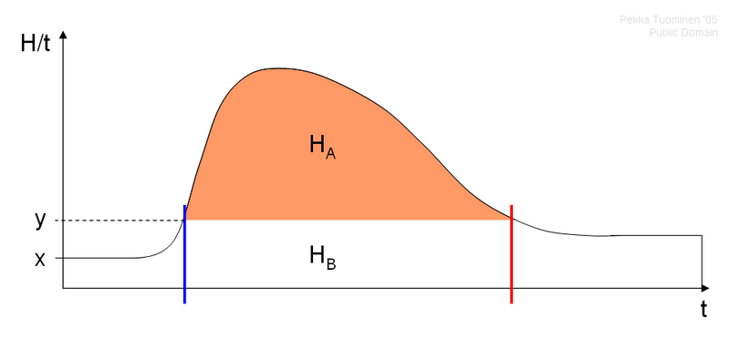
This diagram depicts the effect of a well executed radiation protection plan after a nuclear accident. The y-axis shows dose rate H/t (~radiation level) that a population (e.g. of a city) is exposed to. The x-axis is time t. In the beginning natural background radiation is at level x. As the cloud of radioactive particles passes the population, a sharp rise in radiation level occurs at first, after which the radiation level settles down as the cloud leaves the area due to wind. With effective radiation protection measures, such as sheltering inside buildings, the dose rate that affects the population can be limited to level y, opposed to the high curve. Thus the high dose H sub A, marked with orange color, is averted. Rather the population gets the dose H sub B, marked in white, which is only slightly higher than then natural dose caused by dose rate x. The blue line marks the beginning of the effect of radiation protection measures while the red line marks the end.
Based on Mustonen, R. et al.: Ydinuhkat ja varautuminen, Säteilyturvakeskus, Helsinki, 1995, ISBN 951-712-058-3
File history
Click on a date/time to view the file as it appeared at that time.
| Date/Time | Thumbnail | Dimensions | User | Comment | |
|---|---|---|---|---|---|
| current | 13:47, 3 June 2005 |  | 969 × 450 (13 KB) | Tungsten (talk | contribs) | {{PD-user|Tungsten}} This diagram depicts the effect of a well executed radiation protection plan after a nuclear accident. The y-axis shows dose rate H/t (~radiation level) that a population (e.g. of a city) is exposed to. The x-axis is time t. In the b |
You cannot overwrite this file.
File usage on Commons
The following 2 pages use this file:
File usage on other wikis
The following other wikis use this file:
- Usage on en.wikipedia.org
- Usage on fi.wikipedia.org